Private Pilot · Unit 6 · 30 min
The Traffic Pattern
By the end of this lesson you will know:
- why the runway in use is the one most nearly aligned into the wind, and how that fixes the pattern's orientation
- what a wind cone, a wind tee, a tetrahedron, and a segmented circle each tell you from the air
- the name and position of every leg, and the standard figures for pattern altitude, the descent, and each turn
- which regulation makes left turns the requirement, and the three ways a right-hand pattern is indicated to you
- how to join a nontowered pattern arriving from either side of the airport, and how to leave one
- why the traffic pattern is where mid-air collisions are most likely, and which maneuvers make the risk worse
What the traffic pattern is
A traffic pattern is the traffic flow that is prescribed for aircraft landing at, taxiing on, or taking off from an airport. Its components are the departure leg, the upwind leg, the crosswind leg, the downwind leg, the base leg, and the final approach (Pilot/Controller Glossary).
An airplane in flight cannot be stopped to let conflicting traffic pass, so conflicts in the air have to be prevented rather than resolved. The pattern prevents them by putting every arriving and departing airplane on the same rectangular circuit, in the same direction, at the same altitude. Each airplane's next move is then predictable to every other pilot who can see it (AFH Chapter 8).
Airports come in two types.
- A towered airport has an operating control tower. Pilots operating from one are required to maintain two-way radio communication with air traffic control (ATC) and to acknowledge and comply with its instructions. A pilot who cannot comply must say so and request amended instructions (PHAK Chapter 14).
- A nontowered airport has no operating control tower. Two-way radio communications are not required there, although transmitting your intentions on the published frequency is good operating practice for the benefit of other traffic. That frequency is the common traffic advisory frequency (CTAF), designated for carrying out airport advisory practices at an airport without an operating control tower (PHAK Chapter 14).
Neither arrangement transfers responsibility for collision avoidance. Using a traffic pattern, a service, or a procedure does not diminish your responsibility to see and avoid other aircraft, from the moment you leave the ramp until you return to it (AFH Chapter 8; 14 CFR 91.113(b)).
PHAK Ch 14, "Types of Airports," "Towered Airport," and "Nontowered Airport"; AFH Ch 8, "Airport Traffic Patterns and Operations"; Pilot/Controller Glossary, "Traffic Pattern"; 14 CFR 91.113(b)
Which runway is in use
An airplane flies by airspeed, but it takes off and lands on a finite length of pavement. That is why takeoffs and landings are made into the wind wherever the runways allow. A headwind lets the airplane reach its liftoff airspeed at a lower groundspeed. A headwind equal to 10 percent of the takeoff airspeed shortens the takeoff distance by about 19 percent, and the effect of wind on landing distance is identical (PHAK Chapter 11). Computing those distances from the performance charts belongs to a later unit.
Landing and takeoff should be accomplished on the operating runway most nearly aligned into the wind. If a secondary runway is used, for its length for example, pilots using it should avoid the flow of traffic to the runway most nearly aligned into the wind (AC 90-66C paragraph 11.5). The runway in use then fixes the pattern: which way the legs run, which end you approach, and which end you climb out over.

Runways are laid out according to the local prevailing winds, and a runway number is the whole number nearest one tenth of the magnetic azimuth of the runway centerline, measured clockwise from magnetic north (PHAK Chapter 14). Runway 19 therefore points about 190 degrees magnetic, and the same strip of pavement flown from the other end is Runway 01. Parallel runways, the markings painted on the surface, and the signs beside the pavement are the subject of Airport Markings and Signs, the next lesson in this unit.
PHAK Ch 11, "Takeoff Performance"; PHAK Ch 14, "Runway Markings and Signs" and "Runway Designation Marking"; AC 90-66C paragraph 11.5
Reading the wind from the ground
At an airport with an operating control tower, ATC gives you the wind. It may also come from a flight service station, or from a broadcast on the CTAF. When none is available, you read the wind direction and the runway in use off the field itself. Check the indicators even when a frequency has given you the wind, because there is no assurance that the information provided is accurate (PHAK Chapter 14).
A wind direction indicator is a wind cone, a wind sock, or a wind tee installed near the operational runway to indicate wind direction. The large end of the cone or sock points into the wind, as does the large end of the tee, which is its cross bar (AIM 4-3-4). The cone and the sock are the same fabric device under two names, and only that device reports strength as well as direction: it extends out straighter in strong winds and moves back and forth when the wind is gusting (PHAK Chapter 14).
A tetrahedron is the landing direction indicator, installed when conditions at the airport warrant it, and its small end points in the direction of landing. Pilots are cautioned against using a tetrahedron for any purpose other than as an indicator of landing direction, and specifically against reading wind direction from one. A wind tee or a tetrahedron can be aligned by hand with the runway in use, which is why the cone or sock is the device to read for the wind. At an airport with a control tower, reference the tetrahedron only when the tower is not in operation: tower instructions supersede tetrahedron indications (AIM 4-3-4).
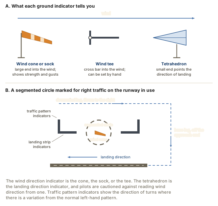
At an airport without an operating control tower, a segmented circle visual indicator system, if installed, is designed to provide traffic pattern information. It is placed where pilots in the air and on the ground can see it, and it gathers four kinds of element in one location:
- the wind direction indicator;
- the landing direction indicator;
- the landing strip indicators, installed in pairs to show the alignment of the landing strips;
- the traffic pattern indicators, arranged in pairs with the landing strip indicators and used to indicate the direction of turns where there is a variation from the normal left traffic pattern.
Where no segmented circle is installed, traffic pattern indicators may be installed on or near the end of the runway (AIM 4-3-4).
AIM 4-3-4; PHAK Ch 14, "Wind Direction Indicators" and "Traffic Patterns"; Pilot/Controller Glossary, "Segmented Circle"
The legs of the pattern
Every position in the circuit has a name, and those names are what a controller or another pilot will use.
- The departure leg begins after takeoff and continues straight ahead along the extended runway centerline. The departure climb continues until reaching a point at least half a mile beyond the departure end of the runway and within 300 feet of the traffic pattern altitude (AIM 4-3-2).
- The crosswind leg is a flight path at right angles to the landing runway off its upwind end, which is the end you departed from (Pilot/Controller Glossary).
- The downwind leg is a flight path parallel to the landing runway in the direction opposite to landing, normally extending between the crosswind leg and the base leg (Pilot/Controller Glossary). It is flown about half a mile to a mile out from the runway (AFH Chapter 8).
- The base leg is a flight path at right angles to the landing runway off its approach end, normally extending from the downwind leg to the intersection of the extended runway centerline (Pilot/Controller Glossary).
- The final approach is a flight path in the direction of landing along the extended runway centerline, normally extending from the base leg to the runway. An aircraft making a straight-in approach under VFR is also considered to be on final approach (Pilot/Controller Glossary).
- The upwind leg is a flight path parallel to the landing runway in the direction of landing, separate and distinct from the departure leg (AC 90-66C Appendix A). It is flown at controlled airports and after go-arounds. On a go-around, once a safe altitude is reached, the pilot makes a shallow-bank turn to the upwind side of the airport, which keeps the runway and aircraft departing from it in the pilot's view (AFH Chapter 8). ATC uses the term for a different path: in the Pilot/Controller Glossary the upwind leg is an extension of the departure leg along the extended runway centerline, used when issuing control instructions for separation, spacing, or sequencing.
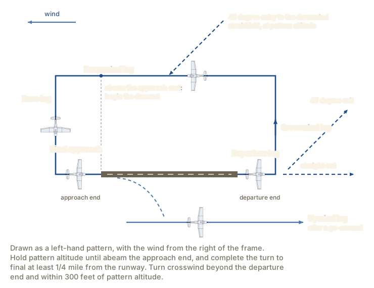
The standard figures for flying that circuit are published as a key to traffic pattern operations in the AIM and in PHAK. For a single runway they are:
- enter the pattern in level flight, abeam the midpoint of the runway, at pattern altitude;
- maintain pattern altitude until abeam the approach end of the landing runway on the downwind leg, then begin the descent and turn base at a point approximately 45 degrees from the approach end of the runway (AC 90-66C paragraph 11.4);
- complete the turn to final at least a quarter of a mile from the runway;
- after takeoff or a go-around, continue straight ahead until beyond the departure end of the runway;
- if remaining in the pattern, begin the turn to the crosswind leg beyond the departure end of the runway and within 300 feet of pattern altitude, and make the turn to downwind at pattern altitude (AC 90-66C paragraph 11.7);
- if departing the pattern, continue straight out, or exit with a 45 degree turn beyond the departure end of the runway after reaching pattern altitude, to the left in a left-hand pattern and to the right in a right-hand pattern.
You may vary the size of the pattern to suit the airplane's performance (AIM 4-3-3), and those figures still set its shape. A pattern flown to them stays close to the runway, which is the geometry the weather minimums lesson relied on when it covered 14 CFR 91.155(b)(2): in Class G airspace below 1,200 feet above the surface, at night, with visibility of at least 1 statute mile, an airplane operating in a traffic pattern within half a mile of the runway may operate clear of clouds.
AIM 4-3-2, 4-3-3; PHAK Ch 14, "Traffic Patterns"; AFH Ch 8, "Standard Airport Traffic Patterns"; AFH Ch 9, "Go-Arounds (Rejected Landings)"; AC 90-66C Appendix A and paragraphs 11.4 and 11.7; Pilot/Controller Glossary, "Traffic Pattern"
Pattern altitude
The traffic pattern altitude (TPA) is the altitude the circuit is flown at, and the use of a common altitude at a given airport is the key factor in minimizing the risk of collisions at airports without operating control towers (AC 90-66C Appendix A). Unless a specific traffic pattern altitude is published in the Chart Supplement entry for the airport, the recommendation is that propeller-driven aircraft enter the pattern at 1,000 feet above the airport surface. Large and turbine-powered airplanes enter at not less than 1,500 feet above the airport elevation, or 500 feet above the established pattern altitude (AIM 4-3-3; AC 90-66C Appendix A). Those altitudes should be maintained unless the distance-from-cloud criteria of 14 CFR 91.155 require otherwise (AIM 4-3-3).
For a large or turbine-powered airplane arriving at an airport in Class D airspace, the 1,500-foot figure is not a recommendation. Unless required by the applicable distance-from-cloud criteria, each pilot operating such an airplane must enter the traffic pattern at an altitude of at least 1,500 feet above the elevation of the airport, and maintain at least 1,500 feet until further descent is required for a safe landing (14 CFR 91.129(e)(1)).
The published figure for a given airport comes from the Chart Supplement U.S., which carries the most comprehensive information available on a public-use airport. It is published in seven volumes organized by region and revised every 56 days (PHAK Chapter 14). When an airport has a published pattern altitude, it appears on the same line as the field elevation.

At most airports and military air bases, traffic pattern altitudes for propeller-driven aircraft generally extend from 600 feet to as high as 1,500 feet above ground level, and patterns for military turbojet aircraft sometimes extend up to 2,500 feet AGL. That is the reason to be constantly alert for aircraft in traffic patterns while en route, and to avoid those areas where you can (PHAK Chapter 14).
AIM 4-3-3; AC 90-66C Appendix A; 14 CFR 91.129(e)(1); PHAK Ch 14, "Traffic Patterns" and "Sources for Airport Data"
The standard traffic pattern is to the left
Unless otherwise authorized or required, each person operating an aircraft on or in the vicinity of an airport in a Class G airspace area must comply with 14 CFR 91.126 (14 CFR 91.126(a)). Its direction-of-turn provision reads: when approaching to land at an airport without an operating control tower in Class G airspace, each pilot of a powered fixed-wing aircraft must make all turns to the left unless the airport displays approved light signals or visual markings indicating that turns should be made to the right, in which case the pilot must make all turns to the right (14 CFR 91.126(b)(1)).
Unless otherwise required by 14 CFR part 93, or otherwise authorized or required by the ATC facility having jurisdiction, each person operating an aircraft on or in the vicinity of an airport in a Class E airspace area must comply with the requirements of 14 CFR 91.126 (14 CFR 91.127(a)). In Class D airspace, each person must comply with both 91.126 and 91.127 in addition to the Class D provisions (14 CFR 91.129(a)). The pattern flow of 91.126 therefore follows you into Class E and Class D airports, particularly where a towered airport is operating as a nontowered one (AC 90-66C paragraph 8.2.1.1).
At an airport with an operating control tower, ATC organizes the pattern: when necessary the tower issues clearances or other information for aircraft to follow the desired flight path, and it can instruct you to enter at any point or to make a straight-in approach instead of a rectangular circuit (AIM 4-3-2; AFH Chapter 8). Except when conducting a circling approach under 14 CFR part 97, or unless otherwise required by ATC, each pilot must circle the airport to the left if operating an airplane (14 CFR 91.129(f)(1)). Two-way radio contact with the tower is required while you operate within the Class B, Class C, or Class D surface area, unless the tower authorizes otherwise (AIM 4-3-2). In all instances an appropriate clearance must be received from ATC before you take off or land (14 CFR 91.129(i)).
A right-hand pattern is indicated to you in three ways.
- The traffic pattern indicators on the field. When approaching for landing, all turns must be made to the left unless a traffic pattern indicator indicates that turns should be made to the right, and the indicator to read is the one for the approach end of the runway you intend to use. Mentally enlarging that indicator makes the base and final legs apparent, and treating the indicator at the departure end the same way gives the direction of turn after takeoff (AIM 4-3-4). This is the only one of the three that works with no radio and no publication aboard, which is what panel B of the figure above is drawn to show.
- The Chart Supplement entry. A runway flown with right turns carries the remark Rgt tfc. in its runway line.
- The sectional chart. Right traffic patterns are indicated at public-use and joint-use airports by the abbreviation RP, followed by the runway numbers concerned, at the bottom of the airport data block. Right traffic patterns are not shown at airports with full-time control towers (AIM 4-3-3). Reading the rest of that data block is the subject of Reading the Sectional Chart, later in this unit.
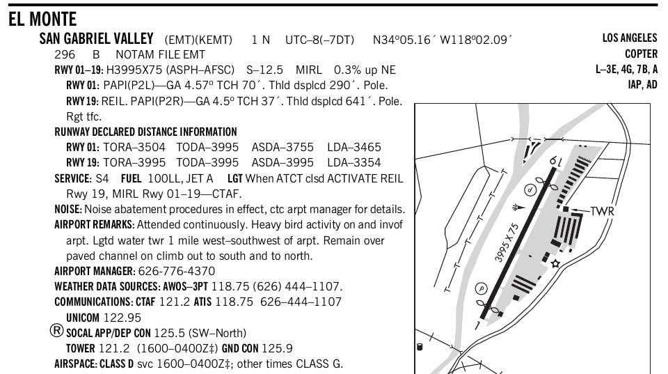
El Monte's entry prints no traffic pattern altitude, so the advisory circular's recommendation applies: propeller-driven aircraft enter at 1,000 feet above the airport surface (AC 90-66C Appendix A).
14 CFR 91.126(a), 91.126(b)(1), 91.127(a), 91.129(a), 91.129(f)(1), 91.129(i); AIM 4-3-2, 4-3-3, 4-3-4; AC 90-66C paragraphs 8.2.1.1 and Appendix A
Entering and leaving the pattern
Nontowered airport traffic patterns are always entered at pattern altitude, and how you enter depends on the direction you arrive from (PHAK Chapter 14). Before you enter, stay out of the flow of traffic until established on the entry leg. You can read the wind and landing direction indicators from an altitude above the pattern, or listen to what other traffic is reporting for the runway in use, and then proceed to a point well clear of the pattern before descending to and entering at pattern altitude (AC 90-66C paragraph 11.2).
Arriving from the downwind side, the preferred method is to approach on a course 45 degrees to the downwind leg and join the pattern at midfield, aimed at a point abeam the midpoint of the runway to be used for landing. Be at pattern altitude with enough time to view the entire pattern before entering, because entries flown while descending may create collision hazards (AC 90-66C paragraph 11.3).
Arriving from the upwind side, you are on the opposite side of the airport from the downwind leg. There are two accepted entries from that side.
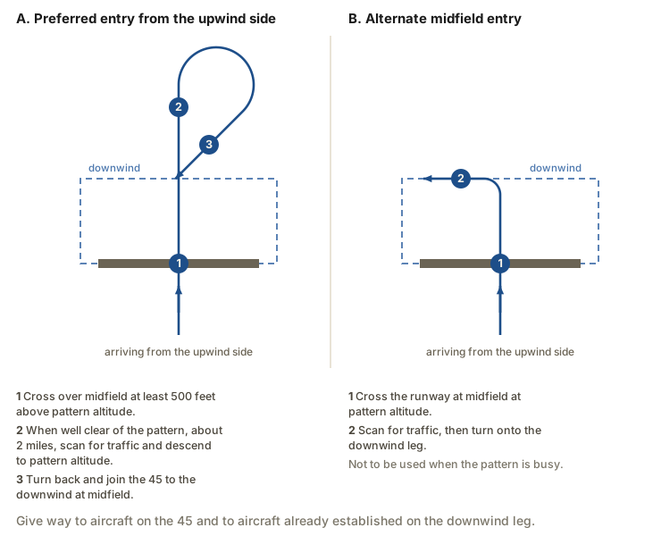
The preferred method is to announce your intentions and cross over midfield at least 500 feet above pattern altitude, which puts the crossing normally at 1,500 feet AGL. If large or turbine aircraft operate at the airport, it is better to remain 2,000 feet AGL so as not to conflict with their pattern. When well clear of the pattern, approximately 2 miles, scan carefully for traffic, descend to pattern altitude, and then turn right to enter at 45 degrees to the downwind leg at midfield (PHAK Chapter 14; AFH Chapter 8). The 45 is preferred because a pilot on the 45 who finds conflicting traffic can keep turning away from the downwind, fly a safe distance out, and come back for another attempt, scanning throughout (AFH Chapter 8).
That right turn in a left-hand pattern is not a violation of the direction-of-turn rule. 14 CFR 91.126(b) governs an aircraft in the traffic pattern, and an aircraft crossing over midfield above pattern altitude to enter the pattern is not in it yet (AC 90-66C paragraph 8.2.1.1).
The alternate method is to enter on a midfield crosswind at pattern altitude, scan carefully for traffic, announce your intentions, and then turn downwind. It should not be used if the pattern is busy. Under either method, give way to aircraft on the preferred 45 degree entry and to aircraft already established on the downwind leg (PHAK Chapter 14).
After takeoff, continue straight ahead until beyond the departure end of the runway. To leave the pattern from there, either continue straight out or exit with a 45 degree turn toward the pattern side after reaching pattern altitude, watching for traffic entering the pattern before you start the turn (AC 90-66C paragraphs 11.6 and 11.8). At an airport with an operating control tower, each pilot must comply with any departure procedures established for that airport by the FAA (14 CFR 91.129(g)(1)).
Adjust course and speed before joining the downwind, and set power there or earlier to match the traffic you are following. The speeds recommended by the manufacturer generally fall between 70 and 90 knots for typical piston single-engine airplanes (AFH Chapter 8). The speed limits of 14 CFR 91.117 apply in the pattern. Position reports on the CTAF, and the words of the calls themselves, are the subject of Radio Communications later in this unit. The calls at a towered airport are the subject of Communicating with Air Traffic Control.
PHAK Ch 14, "Nontowered Airport"; AFH Ch 8, "Non-Towered Airports"; AC 90-66C paragraphs 8.2.1.1, 11.2, 11.3, 11.6, 11.8; AIM 4-3-3; 14 CFR 91.126(b), 91.129(g)(1)
Where the collisions happen
The pattern concentrates airplanes of different performance into one small volume at one altitude, all converging on one strip of pavement. According to the National Transportation Safety Board, the most probable cause of mid-air collisions is the pilot failing to see and avoid other aircraft. Nearly all such accidents occur at or near uncontrolled airports and at altitudes below 1,000 feet, and most reported mid-air collisions occur on the final or short-final approach leg (AFH Chapter 8).
Mid-air collisions generally occur in daylight, 56 percent of them in the afternoon and 32 percent in the morning, against 2 percent at night, dusk, or dawn, and most occur in good visibility. A collision is most likely between two aircraft going in the same direction, and pilots of every experience level are involved (AFH Chapter 8).
Same-direction traffic presents little relative motion, so an airplane you are overtaking on the downwind can sit almost motionless in your windshield until it fills it. The airframe also hides traffic: a high-wing airplane has restricted visibility above, a low-wing airplane has limited visibility below, and the worst case is a low-wing airplane above a high-wing one. Banking from time to time uncovers those blind spots, as does checking the doorposts and looking behind you (AFH Chapter 8).
The last hazard is the one you create for others. ATC service is based on observed or known traffic, and controllers sequence arrivals and departures by requiring aircraft to adjust their flight for spacing. A controller can anticipate minor maneuvering such as shallow S turns; a controller cannot anticipate a major maneuver such as a 360 degree turn, which after a landing sequence has been issued opens a gap and starts a chain reaction through the following traffic. Except when the controller requests it or in an emergency, a 360 degree turn should never be executed in the traffic pattern, or while receiving radar service, without first advising the controller (AIM 4-3-5). At a nontowered airport, pilots are encouraged to use the standard pattern. A pilot who chooses a straight-in approach should not disrupt the flow of arriving and departing traffic, and pilots in the pattern should stay alert for aircraft flying straight in (AIM 4-3-3).
AFH Ch 8, "Safety Considerations"; AIM 4-3-3, 4-3-5; 14 CFR 91.113(b), 91.113(g)
What the rest of this unit adds
This lesson has covered the pattern itself: the runway in use and its alignment into the wind, the indicators that report the wind, the legs and their standard figures, the altitude they are flown at, the regulation behind the direction of turns, and the entries and departures.
- Airport Markings and Signs covers runway numbering in full, the runway and taxiway markings, the holding position markings, and the six types of signs posted beside the pavement.
- Airport Lighting and Wake Turbulence covers the airport beacon, the airport and runway lighting, the visual glideslope indicators, and wake turbulence avoidance.
- Radio Communications covers the position reports made on the CTAF, the words of a self-announce call, and the automatic terminal information service (ATIS) and the automated weather stations.
- Communicating with Air Traffic Control covers towered-airport phraseology, the taxi clearance and its readback, the light gun signals for a radio failure, and compliance with ATC instructions under 14 CFR 91.123, which is the airport-vicinity rule the operating rules lesson held for this unit.
- Reading the Sectional Chart covers the airport symbol, the RP notation that marks a right-hand pattern, and the rest of the chart legend.
You know the runway, the entry, the direction of the turns, and the width of the turn to final before the airplane needs any of them.
- Read the wind before you commit to a runway. The cone or sock is the device that reports strength and gusts; a tee or a tetrahedron may have been set by hand.
- Arrive at pattern altitude, on the 45, at midfield. Descending into the pattern is how one airplane arrives on top of another, and 1,000 feet above the airport surface is the recommendation wherever the Chart Supplement publishes nothing else.
- Check the Chart Supplement entry for the field before you go. A runway line ending in Rgt tfc. means every turn there is a right turn, and 14 CFR 91.126(b)(1) makes that mandatory rather than advisory.
- Fly the turn to final wide and unhurried. Complete it at least a quarter of a mile out, and if it would put you close to an airplane already on final, go around rather than tighten it.
Check your understanding
Answer from memory, without scrolling back up. Recalling it yourself is what makes it stick.
Approaching to land at a nontowered airport in Class G airspace, you must?
Each pilot of a powered fixed-wing aircraft must make all turns to the left unless the airport displays approved light signals or visual markings indicating that turns should be made to the right. (14 CFR 91.126(b)(1))
Left is the requirement, not a preference, and only approved light signals or visual markings at the airport change it. The runway in use follows the wind. The direction of turn does not.
With no radio and no publications aboard, what shows you right traffic?
Traffic pattern indicators are arranged in pairs with the landing strip indicators and indicate the direction of turns where the pattern varies from the normal left pattern. (AIM 4-3-4)
The tetrahedron gives the direction of landing and the cone gives the wind. Neither reports which way the pattern turns; the traffic pattern indicators do.
The small end of a tetrahedron points in which direction?
The small end of the tetrahedron points in the direction of landing, and pilots are cautioned against using one for any other purpose. (AIM 4-3-4)
A tetrahedron indicates nothing but landing direction. It can be set by hand, so it is not a wind indicator, and it says nothing about the downwind leg.
Which publication gives a specific airport's traffic pattern altitude?
The Chart Supplement U.S. carries the most comprehensive information on an airport, including its published pattern altitude, and it is revised every 56 days. (PHAK Ch 14; AIM 4-3-3)
The AIM gives the recommendation that applies where nothing is published, and the sectional's data block carries the RP notation. The published altitude for one airport is in the Chart Supplement.
A flight path parallel to the landing runway, opposite to the landing direction, is?
The downwind leg is a flight path parallel to the landing runway in the direction opposite to landing, normally extending between the crosswind leg and the base leg. (Pilot/Controller Glossary)
The upwind leg is parallel to the runway in the same direction as landing, and the crosswind leg lies at right angles to the runway. Opposite to the landing direction is downwind.
Arriving from the downwind side of a nontowered pattern, you should join?
Entry to the downwind should be at a 45 degree angle abeam the midpoint of the landing runway, and nontowered patterns are always entered at pattern altitude. (AC 90-66C paragraph 11.3; PHAK Ch 14)
The angle is 45 degrees and the altitude is pattern altitude before you get there. Entries flown while descending risk descending onto an airplane already in the pattern.
Arriving from the upwind side, the preferred entry crosses midfield?
Cross over midfield at least 500 feet above pattern altitude, and when well clear of the pattern, approximately 2 miles, descend to pattern altitude and turn back to the 45. (PHAK Ch 14; AFH Ch 8)
The crossing is above the pattern, not below it, and the entry rejoins the 45 to the downwind at midfield rather than turning onto base.
Remaining in the pattern after takeoff, you turn crosswind?
Continue straight ahead until beyond the departure end of the runway, then begin the turn to crosswind within 300 feet of pattern altitude. (AIM 4-3-3; AC 90-66C paragraph 11.7)
The 300 feet is measured from pattern altitude, not from the surface, and the turn waits until the airplane is beyond the departure end of the runway.
Two aircraft are approaching an airport to land. Which statement holds?
The aircraft at the lower altitude has the right of way, but it may not take advantage of that rule to cut in front of another which is on final approach to land, or to overtake it. (14 CFR 91.113(g))
Altitude decides, not speed, and it decides in favor of the lower aircraft. What the lower aircraft may not do is use the rule to cut in front of or overtake an aircraft on final.
In Class D airspace with the tower operating, the pattern you fly is?
The tower issues the flight path to follow and may instruct a straight-in. Absent such an instruction, each pilot must circle the airport to the left if operating an airplane. (14 CFR 91.129(f)(1); AIM 4-3-2)
ATC can instruct you to enter at any point or to fly straight in. The left circuit is the default when ATC has directed nothing else, not a limit on what ATC may direct.
Go deeper (primary source): read AC 90-66C, Non-Towered Airport Flight Operations, section 11 and Appendix A, and compare its traffic pattern diagram with AIM 4-3-3. Then look up your home airport in the Chart Supplement and write down its pattern altitude, the runways with right traffic, and the hours of any part-time control tower.