Private Pilot · Unit 5 · 26 min
VFR Weather Minimums
By the end of this lesson you will know:
- what flight visibility, ground visibility, and a ceiling each mean, and which of the three someone else reports to you
- the flight visibility and distance from clouds required in every class of airspace, and what changes at 10,000 feet mean sea level (MSL)
- how the Class G minimums differ by day and by night, and above and below 1,200 feet above the surface
- the two extra conditions that apply inside a surface area when the ceiling is low
- what a special VFR clearance provides, what it requires of you, and where it is not available
- the visibility limits a student pilot flies to, which are not the ones in 14 CFR 91.155
What the numbers mean, exactly
Every requirement in this lesson is written in one of three quantities, and 14 CFR 1.1 defines all three. They are:
- Flight visibility, the average forward horizontal distance, from the cockpit of an aircraft in flight, at which prominent unlighted objects may be seen and identified by day and prominent lighted objects may be seen and identified by night.
- Ground visibility, the prevailing horizontal visibility near the earth's surface as reported by the United States National Weather Service or an accredited observer.
- A ceiling, the height above the earth's surface of the lowest layer of clouds or obscuring phenomena reported as broken, overcast, or obscuration, and not classified as thin or partial. A scattered layer is not a ceiling, however low it sits.
Where a regulation names ground visibility or a ceiling, the number is a reported figure that you have to go and get before the flight. Where a regulation names flight visibility, the number is your own determination in the air. Unit 8 covers where those reports come from and how to read them.
Visibilities are stated in statute miles of 5,280 feet. Airspace radii and chart distances are in nautical miles of 6,076 feet. Your airspeed is in knots, one knot being one nautical mile per hour. Statute miles and nautical miles are not interchangeable: 3 statute miles is 2.6 nautical miles, and 1 statute mile is 0.87 nautical mile. Wherever a weather minimum states a distance in miles, that mile is a statute mile.
Visual meteorological conditions (VMC) are meteorological conditions expressed in terms of visibility, distance from cloud, and ceiling equal to or better than specified minima. Because the specified minima change with the class of airspace and with altitude, the same weather can be VMC at one altitude and not at another.
14 CFR 1.1; PHAK Ch 15, "Basic VFR Weather Minimums"; AIM Pilot/Controller Glossary
The minimums, class by class
14 CFR 91.155(a) prescribes the basic VFR weather minimums in a table. No person may operate an aircraft under visual flight rules (VFR) when the flight visibility is less, or at a distance from clouds that is less, than the figure prescribed for the corresponding altitude and class of airspace.
| Airspace | Flight visibility | Distance from clouds |
|---|---|---|
| Class A | Not applicable | Not applicable |
| Class B | 3 statute miles | Clear of clouds |
| Class C | 3 statute miles | 500 ft below, 1,000 ft above, 2,000 ft horizontal |
| Class D | 3 statute miles | 500 ft below, 1,000 ft above, 2,000 ft horizontal |
| Class E, less than 10,000 ft MSL | 3 statute miles | 500 ft below, 1,000 ft above, 2,000 ft horizontal |
| Class E, at or above 10,000 ft MSL | 5 statute miles | 1,000 ft below, 1,000 ft above, 1 statute mile horizontal |
| Class G, 1,200 ft or less above the surface (regardless of MSL altitude), day | 1 statute mile | Clear of clouds |
| Class G, 1,200 ft or less above the surface (regardless of MSL altitude), night | 3 statute miles | 500 ft below, 1,000 ft above, 2,000 ft horizontal |
| Class G, more than 1,200 ft above the surface but less than 10,000 ft MSL, day | 1 statute mile | 500 ft below, 1,000 ft above, 2,000 ft horizontal |
| Class G, more than 1,200 ft above the surface but less than 10,000 ft MSL, night | 3 statute miles | 500 ft below, 1,000 ft above, 2,000 ft horizontal |
| Class G, more than 1,200 ft above the surface and at or above 10,000 ft MSL | 5 statute miles | 1,000 ft below, 1,000 ft above, 1 statute mile horizontal |
Three entries in that table need explanation.
- Class A is marked not applicable because every operation in Class A airspace is conducted under instrument flight rules (IFR) and under an air traffic control (ATC) clearance (14 CFR 91.135).
- Class B requires 3 statute miles and nothing more than clear of clouds. Inside Class B, ATC provides separation services to every aircraft it has cleared into the airspace (AIM 3-2-3). You may fly just outside a cloud there, which no other class of controlled airspace permits, subject to your continuing duty to see and avoid other aircraft (14 CFR 91.113(b)).
- Class C, Class D, and Class E below 10,000 feet MSL share one set of figures: 3 statute miles, 500 feet below, 1,000 feet above, 2,000 feet horizontal. Those four numbers apply in most of the airspace a training flight uses.
14 CFR 91.155(a); PHAK Ch 15, "Basic VFR Weather Minimums" and Figure 15-8; AIM 3-1-4 and TBL 3-1-1
The volume you keep clear of clouds
The three cloud figures together describe one volume of air around the airplane that must contain no cloud. Below 10,000 feet MSL in Class C, Class D, or Class E, that volume reaches 500 feet down, 1,000 feet up, and 2,000 feet out in every lateral direction, straight ahead as well as to either side. The horizontal figure binds first in level flight, because forward speed closes the distance to a cloud ahead far faster than a climb or descent closes the distance to one above or below.
The vertical figures set your cruising altitude under a layer. Suppose the base of the layer above you is at 4,000 feet MSL, over terrain near sea level. Keeping 500 feet beneath it puts your highest usable altitude at 3,500 feet MSL. That is also a legal VFR cruising altitude on an easterly course, because the cruising-altitude rule requires an odd thousand plus 500 feet on a magnetic course of 0 through 179 degrees when you are more than 3,000 feet above the surface (14 CFR 91.159(a)(1)).
14 CFR 91.155(a), 91.159; PHAK Ch 15, "Basic VFR Weather Minimums"
What changes at 10,000 feet MSL
At or above 10,000 feet MSL the requirement grows in both quantities. The flight visibility becomes 5 statute miles, and the distance from clouds becomes 1,000 feet below, 1,000 feet above, and 1 statute mile horizontal (14 CFR 91.155(a)). The horizontal figure changes most: 1 statute mile is 5,280 feet, so the lateral clearance grows by a factor of 2.6.
The threshold is an MSL altitude, read straight off the altimeter with the current altimeter setting dialed in. Crossing 10,000 feet MSL in a climb changes the numbers you are flying to, whether the terrain below is at sea level or at 6,000 feet.
The same altitude appears in the speed limit of 14 CFR 91.117(a), which the operating-rules lesson covered: below 10,000 feet MSL no person may operate an aircraft at more than 250 knots indicated, and that cap does not apply above it.
Where you are more than 1,200 feet above the surface and at or above 10,000 feet MSL, Class G requires 5 statute miles with 1,000 feet below, 1,000 feet above, and 1 statute mile horizontal, exactly as Class E does.
14 CFR 91.155(a), 91.117(a); AIM 3-1-4
Class G by day and by night
Class G airspace is the one class whose minimums depend on the time of day. Class G has three altitude bands: within 1,200 feet of the surface, more than 1,200 feet above the surface but below 10,000 feet MSL, and more than 1,200 feet above the surface at or above 10,000 feet MSL. In the first two bands the figures differ by day and by night. In the third they do not.
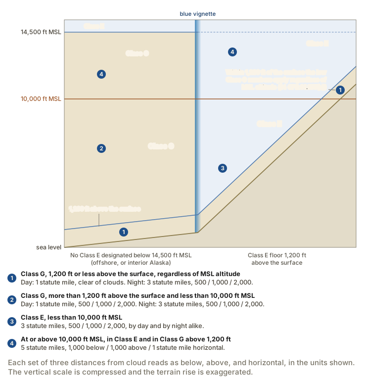
The ground at the left of the figure, with no Class E designated below 14,500 feet MSL, is the case the previous lesson placed offshore and in interior Alaska rather than over the contiguous states.
Two boundaries divide the Class G figures: the onset of night, and the height of 1,200 feet above the surface.
- Day and night change both quantities within 1,200 feet of the surface. By day, Class G there requires 1 statute mile and clear of clouds. At night the same airspace requires 3 statute miles with the full 500, 1,000, and 2,000 foot clearances.
- Crossing 1,200 feet above the surface changes the day figures only. Above 1,200 feet and below 10,000 feet MSL, the day requirement stays at 1 statute mile of visibility but adds the 500, 1,000, and 2,000 foot cloud clearances. The night requirement is the same on both sides of that height: 3 statute miles with the full clearances.
The regulation writes the low Class G row as "1,200 feet or less above the surface (regardless of MSL altitude)" (14 CFR 91.155(a)). Over terrain at 10,500 feet, an airplane at 11,300 feet MSL is 800 feet above the surface, so it is flying to the low Class G figures even though the altimeter reads above 10,000 feet.
The word night in 14 CFR 91.155 is the definition in 14 CFR 1.1: the time between the end of evening civil twilight and the beginning of morning civil twilight. That is not the sunset-to-sunrise span that governs position lights under 14 CFR 91.209(a), and it is not the span beginning one hour after sunset that governs night currency to carry passengers under 14 CFR 61.57(b). The lesson on currency laid the three windows on one timeline. The civil twilight boundary puts the 3-statute-mile night figure in effect roughly half an hour after sunset rather than at sunset.
14 CFR 91.155(a), 91.155(b); 14 CFR 1.1; AIM 3-1-4
Which set of numbers applies to you
A number from the table is useless until you know which class of airspace you are in, and at low altitude that turns on where the Class E floor sits over the ground beneath you. The previous lesson gave every floor Class E can have and the symbol that marks each one on the sectional aeronautical chart.
Suppose you are crossing ground on the faint side of a magenta vignette, which means the Class E floor there is 700 feet above the surface.
- At 1,500 feet above the surface you are in Class E, below 10,000 feet MSL. You need 3 statute miles of flight visibility with 500 feet below, 1,000 feet above, and 2,000 feet horizontal from any cloud.
- At 500 feet above the surface you are in Class G, within 1,200 feet of the surface. By day, 1 statute mile and clear of clouds is enough for 14 CFR 91.155. Whether you may fly that low at all is a separate question answered by the minimum safe altitudes of 14 CFR 91.119.
For the purpose of 14 CFR 91.155, an aircraft operating at the base altitude of a Class E airspace area is considered to be within the airspace directly below that area (14 CFR 91.155(e)). At exactly 700 feet above the surface in the example above, that provision places you in the Class G below rather than in the Class E whose floor you are touching.
14 CFR 91.155(e), 91.119; FAA Aeronautical Chart Users' Guide, "Airspace"
Inside a surface area: the ceiling and the reported visibility
Two conditions apply on top of the table wherever controlled airspace is designated to the surface for an airport. That means a Class B surface area, a Class C surface area, a Class D surface area, or a Class E surface area. It does not mean the ordinary Class E whose floor is 700 or 1,200 feet above the ground, because that airspace is not designated to the surface.
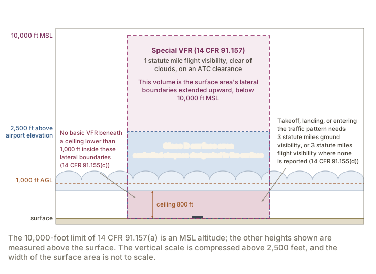
The first condition is about the ceiling. Except as provided in 14 CFR 91.157, no person may operate an aircraft beneath the ceiling under VFR within the lateral boundaries of controlled airspace designated to the surface for an airport when the ceiling is less than 1,000 feet (14 CFR 91.155(c)). An 800-foot overcast over a Class D airport closes the airspace beneath it to basic VFR flight, even on a day when the visibility below the layer is 10 statute miles and you could hold 500 feet of clearance easily.
The second condition is about the reported visibility. Except as provided in 14 CFR 91.157, no person may take off or land an aircraft, or enter the traffic pattern of an airport, under VFR within the lateral boundaries of the surface areas of Class B, Class C, Class D, or Class E airspace designated for an airport unless one of the following is true (14 CFR 91.155(d)):
- ground visibility at that airport is at least 3 statute miles;
- ground visibility is not reported at that airport, and flight visibility during landing or takeoff, or while operating in the traffic pattern, is at least 3 statute miles.
Where the airport reports ground visibility, that reported figure governs, and your own assessment from the cockpit does not substitute for it. A tower reporting 2 statute miles closes the airport to basic VFR arrivals and departures.
14 CFR 91.155(c), 91.155(d); PHAK Ch 15, "Basic VFR Weather Minimums"; AIM 3-1-4
Special VFR
Both of the conditions above, and the whole 14 CFR 91.155 table with them, can be replaced by an ATC clearance. A special VFR clearance permits VFR flight with as little as 1 statute mile of flight visibility while remaining clear of clouds (14 CFR 91.157(b)).
Special VFR operations may be conducted under the minimums of 14 CFR 91.157, instead of those in 91.155, "below 10,000 feet MSL within the airspace contained by the upward extension of the lateral boundaries of the controlled airspace designated to the surface for an airport" (14 CFR 91.157(a)). The volume is the surface area's footprint carried straight up to 10,000 feet MSL, which reaches well above the upper limit of a Class D area. AIM 4-4-6 describes the clearance as effective "within Class B, Class C, Class D, and Class E surface areas." The volume the regulation describes is the larger of the two.
Special VFR operations may only be conducted under four conditions (14 CFR 91.157(b)). They are:
- with an ATC clearance;
- clear of clouds;
- when flight visibility is at least 1 statute mile;
- between sunrise and sunset, or in Alaska when the sun is 6 degrees or less below the horizon, unless the pilot meets the applicable requirements for instrument flight under Part 61 and the aircraft is equipped as required by 14 CFR 91.205(d).
Taking off or landing adds a reported-visibility condition of its own, parallel to the one in 91.155(d) but with a lower figure. No person may take off or land an aircraft under special VFR unless ground visibility is at least 1 statute mile, or, where ground visibility is not reported, unless flight visibility is at least 1 statute mile (14 CFR 91.157(c)). A pilot's own determination of visibility under that second option is not an official weather report or an official ground visibility report (14 CFR 91.157(d)).
Six facts about the clearance in practice come from AIM 4-4-6:
- You have to ask. Where a control tower lies within the Class B, Class C, or Class D surface area, the request goes to the tower. In a Class E surface area, the clearance may be obtained from the nearest tower, flight service station, or air route traffic control center.
- No complete flight plan is needed, though you should state your intentions in enough detail for the controller to fit the flight into the traffic flow.
- The clearance names no altitude, because you must remain clear of clouds. A controller may restrict you to at or below a certain altitude for traffic, and that altitude will still permit flight at or above the minimum safe altitude.
- Terrain and obstacle clearance remain yours. The minimum safe altitudes of 14 CFR 91.119 apply to a special VFR flight exactly as they apply to any other.
- ATC separates special VFR flights from each other and from IFR flights, and that separation stops the moment you leave the surface area.
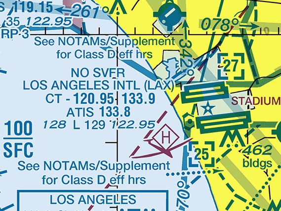
- Fixed-wing special VFR is prohibited at 33 airports, listed in 14 CFR part 91 appendix D section 3, because of the volume of IFR traffic there. Each one prints NO SVFR at the top of its airport data block, the stack of text the chart prints beside the airport symbol with the airport's name and frequencies.
Between sunset and sunrise, 14 CFR 91.157(b)(4) requires a fixed-wing special VFR operation to have a pilot who meets the applicable requirements for instrument flight under Part 61 and an aircraft equipped as required by 14 CFR 91.205(d). A private pilot without an instrument rating does not meet the first of those two requirements, so special VFR between sunset and sunrise is not available to you however the aircraft is equipped.
14 CFR 91.157; 14 CFR part 91 appendix D section 3; AIM 4-4-6; FAA Aeronautical Chart Users' Guide
The limits a student pilot flies to
A student pilot may not act as pilot in command of an aircraft with a flight or surface visibility of less than 3 statute miles during daylight hours or 5 statute miles at night (14 CFR 61.89(a)(6)). A student pilot may also not act as pilot in command when the flight cannot be made with visual reference to the surface (14 CFR 61.89(a)(7)). The certificates lesson covered the rest of 61.89.
Both limits bind in every class and at every altitude. Below 10,000 feet MSL, 91.155 would permit 1 statute mile in Class G by day and 3 statute miles at night. The student figures of 3 and 5 govern instead. Flight and surface visibility are 61.89(a)(6)'s own words for what you see from the cockpit and what is observed at the airport. The lower of the two governs.
14 CFR 61.89(a)(6), 61.89(a)(7)
What the rest of this unit adds
Two lessons remain in this unit. The next one covers the special use airspace areas:
- prohibited, restricted, warning, and alert areas;
- military operations areas;
- controlled firing areas.
The one after it covers the other airspace areas:
- temporary flight restrictions;
- military training routes;
- terminal radar service areas;
- national security areas;
- air defense identification zones and the Defense VFR flight plan;
- published VFR routes;
- the special flight rules areas, including the one charted around Los Angeles International.
Check your understanding
Answer from memory, without scrolling back up. Recalling it yourself is what makes it stick.
A reported ceiling is the height of the lowest layer reported as?
A ceiling is the height above the surface of the lowest layer of clouds or obscuring phenomena reported as broken, overcast, or obscuration, and not classified as thin or partial. (14 CFR 1.1)
A scattered layer is not a ceiling however low it sits, and a layer classified as thin or partial is excluded by the definition in 14 CFR 1.1.
In Class E airspace below 10,000 feet MSL, basic VFR flight requires?
Class E below 10,000 feet MSL requires 3 statute miles of flight visibility with 500 feet below, 1,000 feet above, and 2,000 feet horizontal. (14 CFR 91.155(a))
The visibility is 3 statute miles, and the vertical clearances are 500 feet below the cloud and 1,000 feet above it, not the reverse.
In Class E airspace at or above 10,000 feet MSL, basic VFR flight requires?
At or above 10,000 feet MSL the figures become 5 statute miles with 1,000 feet below, 1,000 feet above, and 1 statute mile horizontal. (14 CFR 91.155(a))
Both quantities grow at that altitude: the visibility goes to 5 statute miles and the clearance below the cloud goes from 500 feet to 1,000 feet.
Basic VFR flight in Class B airspace requires?
Class B requires 3 statute miles of flight visibility and nothing more than clear of clouds, because ATC is separating the traffic it has cleared into the airspace. (14 CFR 91.155(a))
The visibility figure is 3 statute miles, and Class B is the only class of controlled airspace whose cloud requirement is clear of clouds rather than a set of measured distances.
In Class G at 1,000 feet above the surface, by day, you need?
Within 1,200 feet of the surface, by day, Class G requires 1 statute mile of flight visibility and clear of clouds. (14 CFR 91.155(a))
The 3-statute-mile figure is the night requirement in that airspace, and by day the measured cloud clearances begin above 1,200 feet from the surface.
In Class G at 2,000 feet above the surface, at night, you need?
The Class G night figures are the same on both sides of 1,200 feet above the surface: 3 statute miles with 500 feet below, 1,000 feet above, and 2,000 feet horizontal. (14 CFR 91.155(a))
Crossing 1,200 feet above the surface changes the day figures only. At night the requirement is 3 statute miles with the 500, 1,000, and 2,000 foot clearances either side of that height.
Flying 800 feet above terrain that stands at 10,500 feet MSL, in Class G by day, you need?
The low Class G row applies 1,200 feet or less above the surface regardless of MSL altitude, so 800 feet above the ground carries the day figure of 1 statute mile clear of clouds. (14 CFR 91.155(a))
The altimeter reading does not decide this one. The Class G row for 10,000 feet MSL applies only where you are also more than 1,200 feet above the surface.
An overcast layer sits 800 feet above a Class D airport. Inside its boundaries you may?
No person may operate beneath the ceiling under VFR within the lateral boundaries of controlled airspace designated to the surface for an airport when the ceiling is less than 1,000 feet, except under 14 CFR 91.157. (14 CFR 91.155(c))
That rule asks nothing about your visibility or your distance from the cloud. A ceiling below 1,000 feet closes the airspace beneath it to basic VFR flight.
Ground visibility at a Class D airport is reported as 2 statute miles. You may?
Inside the surface areas of Class B, C, D, or E designated for an airport, all three of those operations require 3 statute miles of ground visibility, or of flight visibility where none is reported, except under 14 CFR 91.157. (14 CFR 91.155(d))
The rule names takeoff, landing, and traffic-pattern entry together, and where the airport reports ground visibility that reported figure governs rather than your own assessment.
Special VFR at night in an airplane is permitted only when?
Outside the hours of sunrise to sunset, fixed-wing special VFR requires a pilot who meets the Part 61 requirements for instrument flight and an aircraft equipped per 14 CFR 91.205(d). (14 CFR 91.157(b)(4))
A clearance and 1 statute mile of visibility are required day or night. What the night provision adds is the instrument rating and the IFR equipment.
Go deeper (primary source): read 14 CFR 91.155 from paragraph (a) through paragraph (e), then 14 CFR 91.157, and note how many times 91.155 points to 91.157 as its exception. Then read AIM 4-4-6 for how a special VFR clearance is requested and what ATC does with it.