Private Pilot · Unit 5 · 25 min
The Airspace System at a Glance
By the end of this lesson you will know:
- the four types of airspace, and which two of them make up the lettered classes A through G
- what controlled airspace does and does not require of you before you enter it
- the vertical limits of Class A and why a private pilot certificate alone does not permit operations there
- the clearance, radio, equipment, and certificate requirements for Class B, Class C, and Class D
- which altitude reference each class boundary uses and how those numbers are printed on a chart
How the airspace is divided
The National Airspace System (NAS) is divided into two categories, regulatory and nonregulatory. Within those categories there are four types. They are:
- controlled airspace;
- uncontrolled airspace;
- special use airspace;
- other airspace.
Four factors determine which category and type a given volume of airspace falls into. They are:
- the complexity or density of aircraft movements;
- the nature of the operations conducted within the airspace;
- the level of safety required;
- the national and public interest.
Controlled and uncontrolled airspace together form the lettered classes A through G. This lesson takes them from the top down through Class D.
Two parts of the regulations govern the classes. They are:
- 14 CFR Part 71, which designates where each class of airspace is. The individual boundaries are listed in FAA Order JO 7400.11, which Part 71 incorporates by reference (14 CFR 71.1).
- 14 CFR Part 91 Subpart B, which carries the rules for operating inside each class.
Where two airspace designations overlap, the operating rules of the more restrictive designation apply, and the order of restriction runs A, B, C, D, E, G (14 CFR 71.9).
PHAK Ch 15, "Introduction"; 14 CFR 71.1, 71.9
What controlled airspace means
Controlled airspace is airspace of defined dimensions within which air traffic control (ATC) service is provided according to the airspace classification. Controlled airspace consists of Class A, Class B, Class C, Class D, and Class E.
What the classification changes is the service ATC provides and what is required of you before you enter:
- Under instrument flight rules (IFR), every operation in any class of controlled airspace requires a filed flight plan and an ATC clearance, and standard IFR separation is provided throughout.
- Under visual flight rules (VFR), only Class B requires an ATC clearance. Class C and Class D require that two-way radio communications be established before you enter. Class E requires nothing at all before entry.
Uncontrolled airspace is airspace in which ATC has no authority or responsibility to control air traffic. In the United States that is Class G. No separation service is provided in it to anyone, IFR or VFR.
Two obligations do not vary by class. They are:
- your duty to see and avoid other aircraft, which applies wherever weather conditions permit (14 CFR 91.113(b)), including inside Class B where ATC is separating you from other traffic;
- your duty to meet a minimum flight visibility and a minimum distance from clouds, though the numbers themselves change with the class and the altitude (14 CFR 91.155).
PHAK Ch 15, "Controlled Airspace" and "Uncontrolled Airspace"; AIM 3-2-1, 3-3-1
Reading an airspace profile
The pitot-static lesson explained that the altimeter, set to the current reported setting, indicates height above mean sea level (MSL). Airspace boundaries use three different references:
- Feet MSL for Class A, for the ceiling and every tier floor of Class B, and for the 14,500-foot layer of Class E. You read these directly off the altimeter.
- Feet above the airport elevation for the ceiling of Class C and Class D, and for the floor of a Class C shelf. These are converted to MSL before they are printed on the FAA VFR Sectional Aeronautical Chart, called a sectional, so what you see there is still an altimeter reading.
- Feet above ground level (AGL) for the low floors of Class E, at 700 feet and 1,200 feet. These are heights above the terrain beneath you, not altimeter readings. The chart marks the limit of each of those areas with a graded band of color called a vignette, and the next lesson gives the rule for reading which side of a band carries the floor it marks.
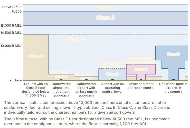
Class E is the default controlled airspace. Class G is the airspace beneath the Class E floor that has not been designated as any other class. Wherever a Class E floor drops, the Class G beneath it gets thinner. Where Class E reaches the surface, there is no Class G at all.
PHAK Ch 15, Figure 15-1; 14 CFR 71.71(a); AIM 3-2-4, 3-2-5, 3-2-6; FAA Aeronautical Chart Users' Guide, "Airspace"
Class A
Class A airspace runs from 18,000 feet MSL up to and including FL600 over the 48 contiguous states, including the airspace over the waters within 12 nautical miles of the coast (14 CFR 71.33(a)). Alaska has the same layer, except that it excludes the airspace below 1,500 feet above the surface and the Alaska Peninsula west of longitude 160 degrees West (14 CFR 71.33(b)). The operating-rules lesson covered the altimeter setting that begins at that altitude: at and above 18,000 feet MSL every aircraft sets 29.92 inches of mercury, and altitudes are then counted as flight levels (FL). FL600 is 60,000 feet.
Every operation in Class A is conducted under instrument flight rules, under an ATC clearance received before entering the airspace (14 CFR 91.135(a)). The aircraft must carry a two-way radio capable of communicating with ATC on an assigned frequency, and the pilot must maintain those communications throughout (14 CFR 91.135(b)). A pilot holding only a private pilot certificate may not operate in Class A airspace, because every operation there is under IFR and no person may act as pilot in command under IFR without an instrument rating (14 CFR 61.3(e)).
Class A is not depicted on any visual chart, because the airspace begins at the same altitude everywhere in the country.
14 CFR 71.33, 91.135; PHAK Ch 15, "Class A Airspace"; AIM 3-2-2
Class B
Class B airspace surrounds the nation's busiest airports, measured by IFR operations or passenger enplanements. It runs generally from the surface to 10,000 feet MSL. Each Class B area is individually tailored. It consists of a surface area over the primary airport plus two or more layers that step outward and upward. The layers are drawn so the airspace contains all published instrument procedures once an aircraft has entered it.
A transponder is a radio that answers an ATC radar interrogation with a coded reply, so the aircraft appears on the controller's display with an identity attached. Mode C is the transponder capability that reports pressure altitude automatically in 100-foot increments, so an altitude readout appears next to the aircraft's symbol on that display. ADS-B Out, short for Automatic Dependent Surveillance-Broadcast Out, broadcasts the aircraft's position, altitude, and velocity, derived from satellite navigation, to ground stations and to nearby aircraft. The Mode C veil is the airspace within 30 nautical miles of an airport listed in appendix D section 1 to Part 91, from the surface up to 10,000 feet MSL. Both a transponder with Mode C and ADS-B Out are required inside it (14 CFR 91.215(b)(2), 91.225(d)(2)).
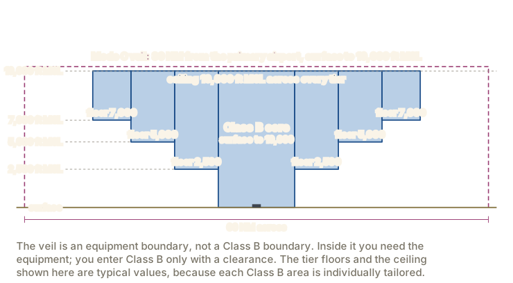
An ATC clearance is required for every aircraft before it operates in Class B airspace, and the clearance must come from the ATC facility having jurisdiction for that area (14 CFR 91.131(a)(1)). The requirement applies regardless of weather conditions and regardless of whether you are landing at the primary airport or merely passing through.
Below Class A, Class B is the only class that requires a particular pilot certificate. No person may take off or land at an airport inside Class B airspace, or operate anywhere within it, unless one of these is true (14 CFR 91.131(b)(1)):
- the pilot in command holds at least a private pilot certificate;
- the pilot in command holds a recreational pilot certificate and has met 14 CFR 61.101(d) or 61.94;
- the pilot in command holds a sport pilot certificate and has met 14 CFR 61.325 or 61.94;
- the aircraft is operated by a student pilot who has met 14 CFR 61.94 or 61.95, as applicable.
Before a solo flight in Class B airspace, a student pilot seeking a private pilot certificate needs all of the following (14 CFR 61.95):
- ground and flight training from an authorized instructor on that specific Class B airspace area, with the flight training received in that airspace;
- a logbook endorsement from the instructor who gave that flight training, dated within the preceding 90 days, stating that the student is proficient to fly solo in that airspace;
- a separate course of training and a separate endorsement for each airport inside the Class B airspace at which the student will operate solo.
At the busiest airports of all, listed in appendix D section 4 to Part 91, no person may take off or land unless the pilot in command holds at least a private pilot certificate (14 CFR 91.131(b)(2)). Los Angeles International, Chicago O'Hare, and Boston Logan are on that list.
Class B requires all of the following equipment:
- an operable two-way radio capable of communicating with ATC on the appropriate frequencies (14 CFR 91.131(c)(2));
- a transponder with automatic altitude reporting (14 CFR 91.131(d)(1));
- ADS-B Out (14 CFR 91.131(d)(2)).
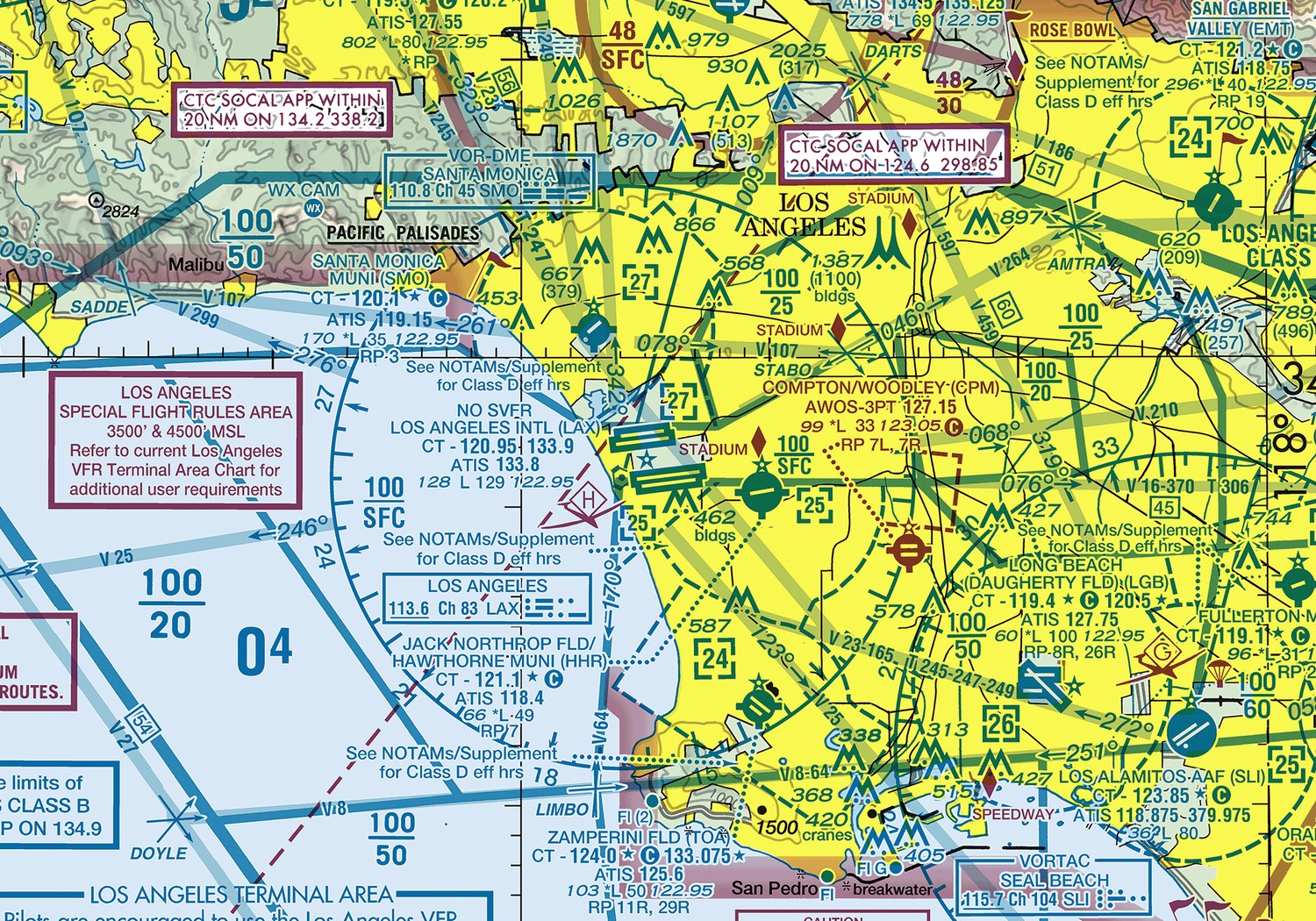
Each dashed blue circle under those shelves encloses a Class D airport with its own control tower. Flying beneath a Class B shelf puts you in the same few thousand feet those airports use, so read the shelf floors before you plan a route under one.
14 CFR 91.131; PHAK Ch 15, "Class B Airspace"; AIM 3-2-3
Class C
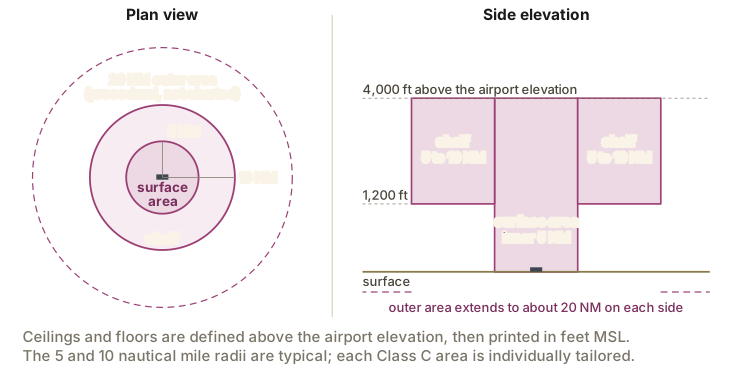
Class C airspace surrounds airports that have an operational control tower, are served by a radar approach control, and have a certain volume of IFR operations or passenger enplanements. It runs generally from the surface to 4,000 feet above the airport elevation, charted in MSL. Each area is individually tailored, but the usual shape is a 5 nautical mile radius surface area from the surface to 4,000 feet above the airport elevation, with a shelf out to 10 nautical miles whose floor is no lower than 1,200 feet above the airport elevation.
Entry requires that two-way radio communications be established with the ATC facility providing air traffic services before you enter the airspace, and maintained while you are inside it (14 CFR 91.130(c)(1)). Call far enough out that you are not across the boundary before the controller answers.
Class C airspace areas also have a procedural outer area, normally reaching 20 nautical miles from the primary airport. Radar service is provided there, and pilot participation in the outer area is voluntary. The outer area is not charted; what is charted is a note in a magenta box giving the approach control frequency to use to establish communications, generally within 20 nautical miles.
The aircraft must carry a two-way radio, a transponder with automatic altitude reporting, and ADS-B Out (14 CFR 91.130(d), referring to 14 CFR 91.215 and 91.225). No specific pilot certificate is required.

14 CFR 91.130; PHAK Ch 15, "Class C Airspace"; AIM 3-2-4
Class D
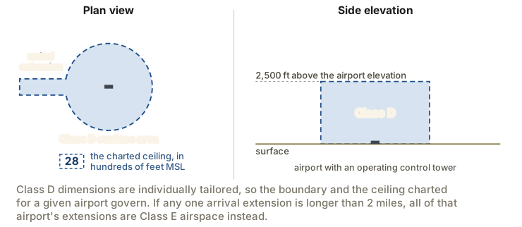
Class D airspace surrounds airports that have an operational control tower. It runs generally from the surface to 2,500 feet above the airport elevation, charted in MSL. The shape is individually tailored to the airport. Where instrument procedures are published, the airspace is normally drawn to contain them, which is why so many Class D areas are a circle with one or two rectangular arrival extensions attached.
If every extension is 2 miles long or less, all of them remain part of the Class D surface area. If any one extension is longer than 2 miles, then all of the extensions become Class E airspace instead, which means you may fly through them without establishing communications.
Entry requires that two-way radio communications be established with the ATC facility providing air traffic services before you enter, and maintained while inside (14 CFR 91.129(c)(1)). The test for "established" is the same one used for Class C. The only equipment the airspace itself requires is an operable two-way radio, and no specific pilot certificate is required.
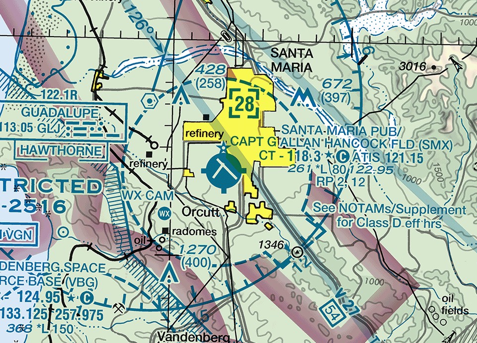
Many towers do not operate 24 hours a day. Where a Class D surface area is part-time, the airspace reverts outside the published hours to either a Class E surface area or Class G airspace. The FAA's Chart Supplement, the volume that lists each airport's data, services, and airspace hours, states which one, in the form "other times CLASS E" or "other times CLASS G." The sectional carries the note "See NOTAMs/Supplement for Class D eff hrs" beside the boundary. When a part-time Class D changes to Class G, the surface area becomes Class G up to but not including the overlying controlled airspace, which is normally the Class E airspace whose floor is at 700 or 1,200 feet AGL.
14 CFR 91.129; PHAK Ch 15, "Class D Airspace"; AIM 3-2-5
What the rest of this unit adds
This lesson stops short in four places:
- Class E, Class G, the transponder and ADS-B Out rules, and the airspace symbols on a sectional come in the next lesson;
- the flight visibility and distance-from-cloud minimums for each class, and the special VFR clearance that can substitute for them, come in a later lesson in this unit;
- prohibited, restricted, warning, and alert areas, military operations areas, controlled firing areas, temporary flight restrictions, military training routes, and national security areas come in the last two lessons of this unit;
- the radio calls that get you into Class C or Class D, the traffic pattern, and the full sectional legend come with airport operations, communications, and charts in Unit 6.
Check your understanding
Answer from memory, without scrolling back up. Recalling it yourself is what makes it stick.
Saying that airspace is "controlled" means?
Controlled airspace is airspace within which ATC service is provided according to the classification. Only Class B requires a VFR clearance. (PHAK Ch 15; AIM 3-2-1)
Controlled describes the service provided, not a blanket permission requirement. A VFR pilot enters Class E without a clearance and without a radio call.
A Class C ceiling is defined as 4,000 feet above the airport elevation. On the chart it appears as?
Class C and Class D limits are defined above the airport elevation but charted in MSL, with the last two zeros dropped. (AIM 3-2-4; PHAK Ch 15)
The definition uses the airport elevation, but the printed number is MSL so it matches your altimeter. Only the low Class E floors are given in AGL.
Class A airspace extends from?
Class A runs from 18,000 feet MSL up to and including FL600, and every operation there is under IFR and an ATC clearance. (14 CFR 71.33, 91.135)
The base is 18,000 feet MSL, not AGL and not 14,500, and the top is FL600. The 14,500-foot figure is the Class E floor where nothing lower has been designated.
Approaching Class B, the controller answers with your call sign and a code. You may?
Class B requires an explicit ATC clearance before you operate in the airspace (14 CFR 91.131(a)(1)). Radio contact and a code are not a clearance. (AIM 3-2-3)
Established communications suffice for Class C and Class D, not Class B. Stay outside until you hear that you are cleared into the airspace.
Calling Class C approach, you hear "November Three Four Five, standby." You may?
A reply containing your call sign establishes two-way radio communications, and that is the entry condition for Class C. (AIM 3-2-4; 14 CFR 91.130(c))
Your call sign in the reply is what counts. Only a reply that omits it, or an instruction to remain outside the airspace, keeps you out.
Where two airspace designations overlap, the rules that apply are those of?
The operating rules of the more restrictive designation apply, and the order of restriction runs A, B, C, D, E, G (14 CFR 71.9).
The more restrictive of the two governs, not the one you reach first. Class A is the most restrictive designation in that order and Class G the least.
A student pilot may fly solo inside Class B airspace only after receiving?
Ground and flight training must be given on that Class B area, and the endorsement must name that area and be dated within the preceding 90 days (14 CFR 61.95(a)).
Both the training and the endorsement are tied to the named Class B area, and a separate course of training and endorsement covers each airport inside it (14 CFR 61.95(b)).
The usual Class C shape is a surface area and a shelf with radii of?
The surface area normally reaches 5 NM and the shelf 10 NM, with the shelf floor no lower than 1,200 feet above the airport elevation. (AIM 3-2-4)
The 20 nautical mile figure is the procedural outer area. It is not charted airspace and crossing it requires nothing of you.
Class D airspace normally runs from the surface up to?
Class D runs generally from the surface to 2,500 feet above the airport elevation, and that ceiling is charted in feet MSL. (AIM 3-2-5; PHAK Ch 15)
The 4,000-foot figure belongs to Class C. The Class D ceiling is measured from the airport elevation, not from the terrain beneath you.
A part-time Class D tower closes for the night. The surface area then?
Outside the published hours the surface area becomes either a Class E surface area or Class G, and the Chart Supplement listing states which. (PHAK Ch 15; AIM 3-2-5)
The designation changes when the tower closes. Where it becomes Class G, that Class G reaches only the base of the overlying controlled airspace, normally 700 or 1,200 feet AGL.
Go deeper (primary source): read 14 CFR 91.129, then 91.130, 91.131, and 91.135, in that order, and watch the requirements accumulate from Class D up to Class A. Then read AIM 3-2-2 through 3-2-5, which covers Class A through Class D in plain language.