Private Pilot · Unit 5 · 30 min
Other Airspace Areas
By the end of this lesson you will know:
- which of the two everyday kinds of NOTAM is regulatory, and why a chart cannot show you most temporary flight restrictions
- the three regulations behind the temporary flight restrictions a private pilot most often meets, and the purposes each one serves
- what a four-digit military training route number tells you about the altitudes flown on that route
- why participation in the radar service of a terminal radar service area is voluntary, and what a national security area asks of you
- the difference between a VFR flyway, a VFR corridor, and a Class B VFR transition route
- the altitudes, transponder code, and course 14 CFR 93.95 prescribes in the Los Angeles Special Flight Rules Area, and what a VFR flight into an air defense identification zone requires
The fourth type of airspace
This unit opened by dividing the National Airspace System into four types: controlled airspace, uncontrolled airspace, special use airspace, and other airspace. This lesson covers the fourth.
Other airspace areas is a general term referring to the majority of the remaining airspace (PHAK Chapter 15). The term carries no operating rules of its own. PHAK's list under it runs to fourteen items:
- Local Airport Advisory;
- military training routes (MTRs);
- temporary flight restrictions (TFRs);
- parachute jump aircraft operations;
- published VFR routes;
- terminal radar service areas (TRSAs);
- national security areas (NSAs);
- air defense identification zones (ADIZ) over land and water, and the Defense VFR (DVFR) flight plan needed to fly VFR in one;
- interception procedures, and the use of 121.5 MHz when not already talking to air traffic control (ATC);
- the Flight Restricted Zone near the Capitol and the White House;
- the special awareness training 14 CFR 91.161 requires for VFR flight within 60 nautical miles of the Washington, DC VOR/DME navigation station (identifier DCA);
- wildlife areas, wilderness areas, and national parks, over which flight above 2,000 feet above the surface is requested;
- National Oceanic and Atmospheric Administration marine areas off the coast, which carry a requirement to operate above 2,000 feet above the surface rather than a request;
- tethered balloons for observation and weather recording, which extend on cables up to 60,000 feet.
Local Airport Advisory is a service available only in Alaska, provided within 10 statute miles of an airport where no control tower is operating but where a flight service station (FSS) is located on the airport (AIM 3-5-1). Parachute jump aircraft operations are governed by 14 CFR part 105 and are tabulated in the Chart Supplement. Sites used frequently are depicted on sectional charts, and the jump pilot announces the operation on the common traffic advisory frequency (PHAK Chapter 15; AIM 3-5-4). A tethered balloon is an obstruction to look up on the chart. Two further areas appear on no chart at all. A stationary or moving altitude reservation is announced by an airspace NOTAM, and a nonparticipating VFR flight is permitted to fly through it. ATC assigned airspace segregates the activity inside it from other IFR traffic. Its schedule appears on the FAA special use airspace website, and no NOTAM announces its activation (AIM 3-5-10). Interception procedures and the operating procedures inside the Washington, DC area are not taught in this course, though the 14 CFR 91.161 training requirement is, later in this lesson.
PHAK Ch 15, "Other Airspace Areas," "Local Airport Advisory (LAA)," and "Parachute Jump Aircraft Operations"; AIM 3-5-1, 3-5-4, 3-5-10; 14 CFR part 105
The NOTAM system
The Notice to Airmen (NOTAM) system provides pilots with time critical aeronautical information that is temporary, or information to be published on aeronautical charts at a later date, or information from another operational publication (AIM 5-1-3). A NOTAM is cancelled when its information reaches the chart or when the temporary condition returns to normal status. Each pilot in command must, before beginning a flight, become familiar with all available information concerning that flight (14 CFR 91.103), and NOTAM information is part of what is available (AIM 5-1-3).
Of the four classifications the system uses, two appear routinely in a private pilot's briefing:
- A NOTAM D is disseminated for every navigational facility that is part of the National Airspace System and for every public use aerodrome, seaplane base, and heliport listed in the Chart Supplement. Its subjects are aerodrome conditions, airspace activity, navigational aids, and communications, and each one carries a keyword such as RWY or SVC after the location identifier (AIM 5-1-3).
- An FDC NOTAM, issued by the Flight Data Center, is used when it is necessary to disseminate regulatory information. Amendments to published instrument approach procedures and to current aeronautical charts arrive this way, and so do temporary flight restrictions (AIM 5-1-3).
Regulatory means the notice itself carries the force of a rule. With one exception covered below, a temporary flight restriction has no charted boundary to look up and no altitude printed in any margin; the text of the NOTAM defines it entirely.
The chart excerpt of P-40 in the previous lesson carried a printed CAUTION box directing you to contact Flight Service for the latest flight restriction status and NOTAMs associated with that area. Retrieving NOTAMs, choosing a briefing, and decoding the contractions they are written in belong to Unit 8.
AIM 5-1-3; 14 CFR 91.103; PHAK Ch 15, "Temporary Flight Restrictions (TFR)"
Temporary flight restrictions
A temporary flight restriction is a volume of airspace, designated by an FDC NOTAM, inside which flight is restricted for a stated reason and a stated period (PHAK Chapter 15). The NOTAM opens with the phrase FLIGHT RESTRICTIONS and then gives the location, the effective period, the area in statute miles, the altitudes affected, the FAA coordination facility, and the reason.
Three regulations create the restrictions a private pilot most often meets. Under 14 CFR 91.137(a), the Administrator will issue a NOTAM designating an area within which temporary flight restrictions apply and specifying the hazard or condition requiring their imposition, on determining that it is necessary in order to:
- protect persons and property on the surface or in the air from a hazard associated with an incident on the surface (14 CFR 91.137(a)(1));
- provide a safe environment for the operation of disaster relief aircraft (14 CFR 91.137(a)(2));
- prevent an unsafe congestion of sightseeing and other aircraft above an incident or event which may generate a high degree of public interest (14 CFR 91.137(a)(3)).
What is prohibited then depends on which purpose the NOTAM was issued under. Issued to protect persons and property from a surface hazard, it admits no transit: no person may operate an aircraft in the designated area unless that aircraft is participating in the hazard relief activities, under the direction of the official in charge of on scene emergency response activities (14 CFR 91.137(b)). Issued for disaster relief or for an event drawing sightseers, it permits a short list of operations, among them flight under an ATC approved IFR flight plan (14 CFR 91.137(c), 91.137(d)).
The second regulation is one sentence. No person may operate an aircraft over or in the vicinity of any area to be visited or traveled by the President, the Vice President, or other public figures contrary to the restrictions established by the Administrator and published in a NOTAM (14 CFR 91.141). The restriction moves with the visit.
The third covers gatherings. The FAA will issue a NOTAM designating an area of airspace in which a temporary flight restriction applies in the vicinity of an aerial demonstration or major sporting event (14 CFR 91.145(a)). The airspace is normally limited to a 5 nautical mile radius and 17,000 feet MSL for a demonstration by high performance aircraft, and to a 3 nautical mile radius and 2,500 feet above the surface for a sporting event (14 CFR 91.145(e)). The NOTAM is issued at least 30 days in advance unless the FAA finds good cause for a shorter period (14 CFR 91.145(f)).
Two further regulations designate a temporary flight restriction the same way. 14 CFR 91.138 covers a declared national disaster area in the State of Hawaii, and 14 CFR 91.143 covers space flight operations (AIM 3-5-3).
One restriction near Los Angeles is neither temporary nor a TFR. It is charted as a Special Security Notice Permanent Continuous Flight Restriction Area: a blue circle on the map face with a boxed note beside it (FAA Aeronautical Chart Users' Guide).
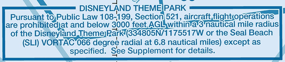
14 CFR 91.137, 91.138, 91.141, 91.143, 91.145; PHAK Ch 15, "Temporary Flight Restrictions (TFR)"; AIM 3-5-3; FAA Aeronautical Chart Users' Guide, "Other Airspace Areas"
Military training routes
A military training route is a route developed jointly by the FAA and the Department of Defense for low-altitude, high-speed military training (AIM 3-5-2). Routes are generally established below 10,000 feet MSL for operations at speeds in excess of 250 knots, and a segment may be defined higher for route continuity, for a descent, for a climbout, or over mountainous terrain (PHAK Chapter 15; AIM 3-5-2).
Each route is identified by two letters and a number. The letters give the flight rules. Operations on an IR route are conducted in accordance with IFR regardless of weather conditions. Operations on a VR route are conducted in accordance with VFR, except that flight visibility must be 5 miles or more and the flight must not be conducted below a ceiling of less than 3,000 feet AGL (AIM 3-5-2).
A route with no segment above 1,500 feet AGL is identified by four number characters, as in VR1207. A route with one or more segments above 1,500 feet AGL is identified by three, as in IR206 (PHAK Chapter 15; AIM 3-5-2). On the chart the designator is printed in solid black on the route centerline, with small arrowheads beside it for the direction of flight (FAA Aeronautical Chart Users' Guide).
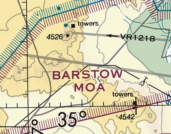
No regulation prohibits a nonparticipating aircraft from flying within a military training route (AIM 3-5-2). What the route tells you is where to expect a fast airplane at low altitude. Your own 250 knot limit below 10,000 feet MSL under 14 CFR 91.117(a) stays in force while that traffic exceeds it, and your duty to see and avoid other aircraft under 14 CFR 91.113(b) is unchanged.
14 CFR 91.117(a), 91.113(b); PHAK Ch 15, "Military Training Routes (MTRs)"; AIM 3-5-2; FAA Aeronautical Chart Users' Guide, "Other Airspace Areas"
Terminal radar service areas
A terminal radar service area is an area where participating pilots can receive additional radar services. The purpose of the service is to provide separation between all IFR operations and participating VFR aircraft (PHAK Chapter 15).
Establishing a TRSA was never subject to the rulemaking process, so TRSAs appear nowhere in 14 CFR part 71, there are no TRSA operating rules in 14 CFR part 91, and a TRSA does not fit into any of the United States airspace classes (AIM 3-5-6).
The primary airport or airports within a TRSA become Class D airspace, and the remaining portion overlies other controlled airspace, normally Class E airspace beginning at 700 or 1,200 feet (PHAK Chapter 15). Entering the Class D core requires two-way radio communications, as it does anywhere. Entering the rest of the TRSA requires no clearance and no radio call. Participation is voluntary, and pilots operating under VFR are encouraged to contact the radar approach control and take advantage of the service (AIM 3-5-6). The service itself, and the call that asks for it, come with Communicating with Air Traffic Control in Unit 6.
The chart draws a TRSA in gray: the outer limit a continuous screened black line, the sectors inside it narrower screened black lines, each sector's altitudes printed in solid black as the MSL ceiling above the MSL floor with the last two zeros removed, and the name near the north position of the area (FAA Aeronautical Chart Users' Guide). The Class D portion keeps its own blue segmented line (PHAK Chapter 15).
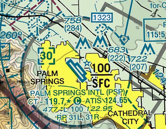
PHAK Ch 15, "Terminal Radar Service Areas (TRSAs)"; AIM 3-5-6; FAA Aeronautical Chart Users' Guide, "Other Airspace Areas"
National security areas
A national security area consists of airspace of defined vertical and lateral dimensions established at a location where there is a requirement for increased security and safety of ground facilities. Pilots are requested to voluntarily avoid flying through a depicted NSA (AIM 3-4-8).
When it is necessary to provide a greater level of security and safety, flight in an NSA may be temporarily prohibited by regulation under the provisions of 14 CFR 99.7, and the prohibition is disseminated by NOTAM (AIM 3-4-8). That section requires each person operating an aircraft in an ADIZ or a Defense Area to comply with special security instructions issued by the Administrator in the interest of national security. Until such a NOTAM exists, no regulation keeps you out.
The chart draws the boundary as a broken magenta line, and an area too small to outline as a small solid magenta shape (FAA Aeronautical Chart Users' Guide).
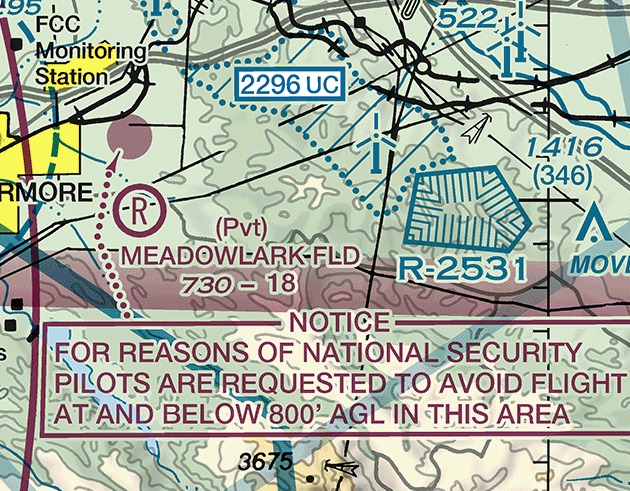
AIM 3-4-8; 14 CFR 99.7; PHAK Ch 15, "National Security Areas (NSAs)"; FAA Aeronautical Chart Users' Guide, "Other Airspace Areas"
Published VFR routes
Published VFR routes exist for transitioning around, under, and through complex airspace such as Class B airspace (AIM 3-5-5). Three are named on charts, and they differ in whether ATC has to authorize you.
- A VFR flyway is a general flight path, not defined as a specific course, for use by pilots in planning flights into, out of, through, or near complex terminal airspace so as to avoid Class B airspace. An ATC clearance is not required to fly one. Flyways are depicted on the reverse side of some VFR Terminal Area Charts (AIM 3-5-5).
- A VFR corridor is airspace through Class B airspace, with defined vertical and lateral boundaries, in which aircraft may operate without an ATC clearance or communication with air traffic control. A corridor is surrounded on all sides by Class B airspace and does not extend down to the surface (AIM 3-5-5). Few were ever built.
- A Class B VFR transition route is a specific flight course depicted and described on a Terminal Area Chart or a VFR Flyway Planning Chart. Communication with ATC is required where the route transitions Class B, Class C, or Class D airspace, and a clearance is required in addition to operate in the Class B airspace itself. Until ATC authorization is received, you must remain clear of the Class B airspace (AIM 3-5-5).
A flyway keeps you outside the Class B airspace, so the Class B clearance requirement of 14 CFR 91.131(a)(1) never arises. A corridor passes through the Class B airspace inside boundaries where no clearance is required (AIM 3-5-5). A transition route goes through the Class B airspace itself, which is why it needs the clearance that airspace has always needed. On initial contact for one, give ATC your position, your altitude, the route name you want, and your direction of flight (AIM 3-5-5).
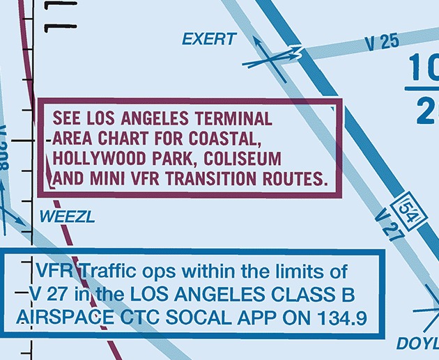
AIM 3-5-5; PHAK Ch 15, "Published VFR Routes"; FAA Aeronautical Chart Users' Guide, "Airspace Information"
Special flight rules areas
14 CFR part 93 prescribes special air traffic rules for aircraft operating within the boundaries of certain designated airspace, and the procedures, operations, size, and traffic density vary among the areas it names (AIM 3-5-7).
A special flight rules area (SFRA) is airspace of defined dimensions, above land areas or territorial waters, within which the flight of aircraft is subject to the rules set forth in 14 CFR part 93, unless otherwise authorized by air traffic control. Not every area listed in part 93 is designated an SFRA, but special air traffic rules apply to all of them (AIM 3-5-7). The chart marks a part 93 airport by boxing the airport's name and draws an SFRA boundary with its own blue symbol (FAA Aeronautical Chart Users' Guide).
Reading one of these areas means reading its subpart, because each subpart is written for one place. Subpart G is the Los Angeles Special Flight Rules Area. Its rules prescribe one course over the ground, two altitudes, and one transponder code.
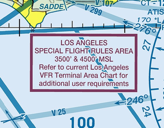
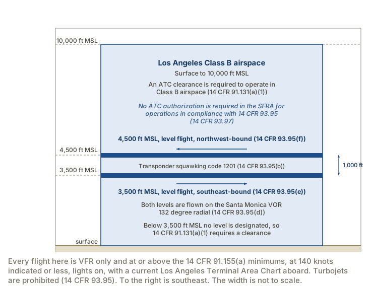
Subpart G prescribes special air traffic rules for aircraft conducting VFR operations in the Los Angeles Special Flight Rules Area (14 CFR 93.91). The area is that part of Area A of the Los Angeles Class B airspace area at 3,500 feet MSL and at 4,500 feet MSL, bounded by Ballona Creek, Manchester Boulevard, the 405 Freeway, Imperial Highway, and the Pacific shoreline (14 CFR 93.93). The area exists only at those two altitudes over that boundary; it is not a continuous block from 3,500 to 4,500 feet MSL.
Unless otherwise authorized by the Administrator, no person may operate an aircraft in that airspace unless the operation is conducted in accordance with the procedures of 14 CFR 93.95. They are:
- the flight is conducted under VFR, and only when it can be conducted in compliance with the basic VFR minimums of 14 CFR 91.155(a) (14 CFR 93.95(a));
- the aircraft is equipped as specified in 14 CFR 91.215(b), replying on code 1201 before entering and while inside the area (14 CFR 93.95(b));
- the pilot has a current Los Angeles Terminal Area Chart in the aircraft (14 CFR 93.95(c));
- the pilot operates on the Santa Monica VOR 132 degree radial (14 CFR 93.95(d));
- aircraft navigating in a southeasterly direction are in level flight at 3,500 feet MSL (14 CFR 93.95(e));
- aircraft navigating in a northwesterly direction are in level flight at 4,500 feet MSL (14 CFR 93.95(f));
- indicated airspeed does not exceed 140 knots (14 CFR 93.95(g));
- anti-collision lights and position lights are on, and use of landing lights is recommended (14 CFR 93.95(h));
- turbojet aircraft are prohibited from VFR operations in the area (14 CFR 93.95(i)).
14 CFR 91.215(b) is the transponder requirement already covered earlier in this unit, and what 93.95(b) adds is the code it replies on. Code 1201 identifies you to the controllers working the traffic above and below as an airplane complying with these rules.
The navigation item names a radial, which is a magnetic bearing extending outward from a navigation station. Holding the 132 degree radial of the Santa Monica VOR puts every airplane in the area on one line over the ground, and the two directions of flight are separated by the 1,000 feet between the levels. Navigating by VOR radials is the subject of Unit 10.
Notwithstanding 14 CFR 91.131(a), an ATC authorization is not required in the Los Angeles Special Flight Rules Area for operations in compliance with 14 CFR 93.95, and all other provisions of 14 CFR 91.131 apply (14 CFR 93.97).
Subpart O prescribes a special air traffic rule for VFR operations in the vicinity of Luke Air Force Base, Arizona, and it prescribes no altitude, code, or course: before operating within the Luke Terminal Area a pilot establishes radio contact with the Luke radar approach control (RAPCON), and maintains two-way radio communication with that facility or an appropriate ATC facility while inside, unless otherwise authorized by ATC (14 CFR 93.175, 93.177(a)). The chart carries that requirement as a boxed note giving the frequency, 118.15 for Luke Approach Control.
Subpart V designates the Washington, DC Metropolitan Area Special Flight Rules Area, the airspace from the surface to but not including flight level 180 within a 30 mile radius of the DCA VOR/DME, which contains the Washington, DC Metropolitan Area Flight Restricted Zone (14 CFR 93.335). One requirement reaches further than the special flight rules area itself does: except as provided in 14 CFR 91.161(e), no person may serve as pilot in command or as second in command of an aircraft while flying within a 60 nautical mile radius of the DCA VOR/DME, under VFR, unless that pilot has completed Special Awareness Training and holds a certificate of training completion (14 CFR 91.161(a)). The training is free on the FAA website (14 CFR 91.161(b)).
14 CFR 93.91, 93.93, 93.95, 93.97, 93.175, 93.177, 93.335, 91.161, 91.215(b), 91.131; AIM 3-5-7, 3-5-8; FAA Aeronautical Chart Users' Guide, "Other Airspace Areas"
Air defense identification zones
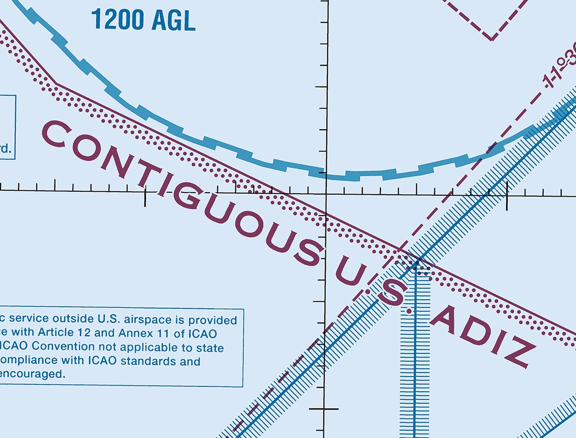
An air defense identification zone is an area of airspace over land or water in which the ready identification, location, and control of all aircraft is required in the interest of national security, excepting Department of Defense and law enforcement aircraft (14 CFR 99.3). Zones are designated in subpart B of part 99, and the contiguous United States ADIZ is described there as one continuous line enclosing a band off the Atlantic, Gulf, and Pacific coasts (14 CFR 99.43).
Defense visual flight rules means a flight within an ADIZ conducted in accordance with the visual flight rules of part 91 (14 CFR 99.3). Three requirements attach to such a flight, and none of them is a weather minimum.
- A radio and a listening watch. A person who operates a civil aircraft into an ADIZ must have a functioning two-way radio, and the pilot must maintain a continuous listening watch on the appropriate aeronautical facility's frequency (14 CFR 99.9(a)). An aeronautical facility means a communications facility where flight plans or position reports are normally filed during flight operations (14 CFR 99.3).
- A DVFR flight plan, filed, activated, and closed. No person may operate an aircraft into, within, or from a departure point within an ADIZ unless the person files, activates, and closes a flight plan with the appropriate aeronautical facility, or is otherwise authorized by ATC (14 CFR 99.11(a)). A flight plan for VFR flight is designated a DVFR flight plan (14 CFR 99.11(c)). It contains the time and point of ADIZ penetration, and the aircraft must depart within five minutes of the estimated departure time it contains (14 CFR 99.9(b)).
- A transponder with altitude reporting. Unless otherwise authorized by ATC, each aircraft conducting operations into, within, or across the contiguous United States ADIZ must be equipped with an operable radar beacon transponder, turned on, replying on a discrete code assigned by ATC or issued by a flight service station, and displaying the aircraft altitude. Code 1200 is not authorized (AIM 5-6-4). The regulation behind that instruction applies to a civil aircraft operating into or out of the United States into, within, or across the contiguous U.S. ADIZ, and it requires a coded radar beacon transponder with automatic pressure altitude reporting equipment that replies to interrogations by transmitting pressure altitude in 100-foot increments (14 CFR 99.13(c)).
A DVFR flight also reports its position before crossing: the time, position, and altitude at the last reporting point before penetration with an estimate for the next one, or, where the route has no appropriate reporting point, the estimated time, position, and altitude of penetration at least 15 minutes beforehand (14 CFR 99.15(b)).
The requirements above are all in subpart A of part 99. Except for 14 CFR 99.7, 99.13, and 99.15, that subpart does not apply to a flight within the 48 contiguous States and the District of Columbia, or within the State of Alaska, that remains within 10 nautical miles of its point of departure (14 CFR 99.1(b)(1)).
14 CFR 99.1, 99.3, 99.7, 99.9, 99.11, 99.13, 99.15, 99.43; AIM 5-6-3, 5-6-4; FAA Aeronautical Chart Users' Guide, "Other Airspace Areas"
What this unit has covered
This unit has now covered all four types of airspace: the controlled classes with the equipment and communication each requires, uncontrolled airspace, the six kinds of special use airspace, and the other airspace areas in this lesson. It has also covered the VFR weather minimums that apply in each class.
Unit 6 takes the airport and the chart themselves: the traffic pattern, runway markings and lighting, the radio calls that establish the communications this unit kept requiring, and a full reading of the sectional.
Temporary flight restrictions, military training routes, terminal radar service areas, and the Los Angeles Special Flight Rules Area each change what your preflight planning has to produce.
- Only temporary flight restrictions relating to national security are charted, so the NOTAMs for the route are the only place a wildfire restriction or a presidential visit appears.
- A military training route marks where a military airplane may be flying above 250 knots at low altitude while 14 CFR 91.117(a) holds you to 250 knots indicated below 10,000 feet MSL. A four-digit identifier puts every segment of the route at or below 1,500 feet above the ground. The route can extend several miles on either side of the charted centerline, and Flight Service holds the actual width.
- A terminal radar service area asks nothing of you outside its Class D core, and a radio call to approach control gets you the radar service inside it.
- In the Los Angeles Special Flight Rules Area, compliance with 14 CFR 93.95 takes the place of a Class B clearance (14 CFR 93.97). Fly it at 3,500 feet MSL southeast-bound or 4,500 feet MSL northwest-bound, on the Santa Monica VOR 132 degree radial, squawking 1201, at 140 knots or less, and no one has to clear you into Class B airspace. Miss any one of those and you are in Class B airspace without a clearance.
Check your understanding
Answer from memory, without scrolling back up. Recalling it yourself is what makes it stick.
A temporary flight restriction is designated by which of these?
An FDC NOTAM designates a TFR, and FDC NOTAMs are the kind used when regulatory information has to be disseminated. (14 CFR 91.137(a); AIM 5-1-3)
Only TFRs relating to national security are charted. Every other one exists as the text of an FDC NOTAM, with no boundary or altitude printed on the chart.
Which regulation restricts flight in the vicinity of the President?
No person may operate an aircraft over or near any area to be visited by the President, the Vice President, or other public figures contrary to the restrictions published in a NOTAM. (14 CFR 91.141)
14 CFR 91.145 covers aerial demonstrations and sporting events, and 14 CFR 91.137 covers disaster and hazard areas. The presidential restriction is its own one-sentence rule.
The military training route VR1218 has four digits, which tells you?
Routes with no segment above 1,500 feet AGL are identified by four number characters. Three characters mean the route includes one or more segments above that height. (AIM 3-5-2)
The digit count reports the highest segment, not the lowest and not the number of segments. Four digits put the whole route at or below 1,500 feet above the ground.
Operations on an IR military training route are conducted how?
Operations on an IR route are conducted in accordance with IFR regardless of weather conditions. The 5 mile visibility figure belongs to VR routes. (AIM 3-5-2)
An IR route is flown under IFR in any weather. A VR route is flown under VFR, with 5 miles of flight visibility and no flight below a ceiling of less than 3,000 feet AGL.
Participation in the radar service inside a terminal radar service area is?
Pilots operating under VFR are encouraged to contact the radar approach control and take advantage of TRSA service, but participation is voluntary. (AIM 3-5-6)
Establishing a TRSA was never subject to rulemaking, so there are no TRSA operating rules in 14 CFR part 91 and nothing requires you to participate in the radar service.
Inside a charted national security area, a pilot is?
Pilots are requested to voluntarily avoid flying through a depicted NSA. Flight in one may be temporarily prohibited under 14 CFR 99.7, and that prohibition arrives by NOTAM. (AIM 3-4-8)
The normal state of an NSA is a request, not a prohibition. A NOTAM is what can turn the request into a prohibition, not the other way around.
Which published VFR route requires a clearance to operate in Class B?
A transition route needs communication with ATC where it transitions Class B, Class C, or Class D, and a clearance in addition to operate in the Class B airspace. (AIM 3-5-5)
A corridor is airspace through Class B in which aircraft may operate without a clearance or communication, and a flyway is a planning path that avoids Class B altogether.
Flying southeastward in the Los Angeles Special Flight Rules Area, you are?
Aircraft navigating in a southeasterly direction are in level flight at 3,500 feet MSL, and the aircraft replies on code 1201 before entering and while inside. (14 CFR 93.95(b), 93.95(e))
4,500 feet MSL is the northwesterly level, and 1200 is the ordinary VFR code. This area assigns its own code, 1201, and pairs each direction with one altitude.
Flying VFR within 60 nautical miles of the DCA VOR/DME requires?
No person may serve as pilot in command or second in command within a 60 nautical mile radius of the DCA VOR/DME under VFR without Special Awareness Training and its certificate. (14 CFR 91.161(a))
The 60 nautical mile requirement is the training and its certificate. Codes and flight plans belong to the operating procedures for the SFRA and the Flight Restricted Zone inside it.
Flying VFR into the contiguous United States ADIZ requires which set?
The requirements are a two-way radio with a continuous listening watch, a DVFR flight plan filed, activated, and closed, and a transponder displaying altitude on a discrete code. (14 CFR 99.9, 99.11, 99.13; AIM 5-6-4)
A VFR flight files a DVFR flight plan rather than an IFR one, and the transponder replies on a discrete code assigned by ATC or issued by a flight service station. Code 1200 is not authorized.
Go deeper (primary source): read 14 CFR part 93 subpart G end to end and count how many of the nine procedures in 93.95 you could comply with in the airplane you are training in. Then read AIM Section 3-5 from 3-5-1 through 3-5-10 and mark which paragraphs cite a regulation and which only describe a service.