Private Pilot · Unit 5 · 26 min
Special Use Airspace
By the end of this lesson you will know:
- what a volume of special use airspace is, and why its designation adds a condition without changing the class of airspace it occupies
- which two of the six kinds are established by regulation, and what each of those two requires of you before you enter
- what activity each of the six kinds contains, and which one is not drawn on a chart at all
- the difference between a using agency and a controlling agency, and which of the two the chart gives you a frequency for
- how the hatched boundary bands and the designations are colored on a sectional aeronautical chart
- how to read an area's altitude limits, its time of use, and its controlling agency out of the tabulation printed in the chart margin
What makes airspace special use
The opening lesson of this unit divided the National Airspace System (NAS) into four types: controlled airspace, uncontrolled airspace, special use airspace, and other airspace. The two lessons since then took the first two. This lesson takes the third.
Special use airspace consists of airspace of defined dimensions identified by an area on the surface of the earth wherein activities must be confined because of their nature, or wherein limitations are imposed upon aircraft operations that are not a part of those activities, or both (14 CFR 73.3(a)).
A special use airspace designation does not replace the class of the airspace it occupies. Inside a restricted area you are still in whatever class of airspace applies there, and that class's weather, radio, and equipment requirements apply unchanged. The designation adds a further condition on top of them.
Special use airspace usually consists of six kinds of area (PHAK Chapter 15). They are:
- prohibited areas;
- restricted areas;
- warning areas;
- military operations areas (MOAs);
- alert areas;
- controlled firing areas (CFAs).
Three things describe any special use airspace area. They are:
- a lateral boundary, the perimeter of the area over the ground;
- a floor and a ceiling, given as feet above mean sea level (MSL) or as flight levels;
- a time of use, the hours during which the designation is in effect.
The chart carries all three for every kind it depicts: the boundary on the map face, and the altitudes and hours in a tabulation printed in the margin (AIM 3-4-1; FAA Aeronautical Chart Users' Guide).
14 CFR 73.3; PHAK Ch 15, "Special Use Airspace"; AIM 3-4-1; FAA Aeronautical Chart Users' Guide, "Special Use Airspace"
Regulatory and nonregulatory
14 CFR part 73 designates special use airspace, and it reaches exactly two of the six kinds: subpart B designates restricted areas and subpart C designates prohibited areas (14 CFR 73.1). Those two are regulatory special use airspace, established through the rulemaking process. Warning areas, MOAs, alert areas, and CFAs are nonregulatory special use airspace (AIM 3-4-1).
No person may operate an aircraft within a restricted area contrary to the restrictions imposed, or within a prohibited area, unless that person has the permission of the using or controlling agency, as appropriate (14 CFR 91.133(a)). Entering either without that permission is a violation of the regulations, separately from any hazard met inside.
No regulation prohibits your entry into a warning area, a military operations area, an alert area, or a controlled firing area, and none requires you to obtain permission before you fly into one. Each of those four is designated because of the activity conducted inside it rather than to place a condition on your entry.
| Area | Category | Required of you before entry | Charted as |
|---|---|---|---|
| Prohibited area | Regulatory | Authorization granted by the using agency | P and a number, in blue |
| Restricted area | Regulatory | Advance permission of the using or the controlling agency, between the designated altitudes and during the time of designation | R and a number, in blue |
| Warning area | Nonregulatory | Nothing | W and a number, in blue |
| Military operations area | Nonregulatory | Nothing | A name followed by MOA, in magenta |
| Alert area | Nonregulatory | Nothing | A and a number, in magenta |
| Controlled firing area | Nonregulatory | Nothing | Not charted |
Prohibited, restricted, and warning areas share one boundary symbol, drawn in blue. Alert areas and military operations areas share a second, drawn in magenta. The designation tells you which of those two you are looking at: a letter and a number for an alert area, a name followed by MOA for a military operations area. In the symbology of the FAA Aeronautical Chart Users' Guide each boundary is a line carrying a band of short ticks turned inward, toward the designated airspace. Each designation is lettered in the color of its own band.
14 CFR 73.1, 91.133(a); AIM 3-4-1; PHAK Ch 15, "Special Use Airspace"; FAA Aeronautical Chart Users' Guide, "Special Use Airspace"
Prohibited areas
A prohibited area contains airspace of defined dimensions within which the flight of aircraft is prohibited. Such areas are established for security or other reasons associated with the national welfare (AIM 3-4-2). No person may operate an aircraft within a prohibited area unless authorization has been granted by the using agency (14 CFR 73.83).
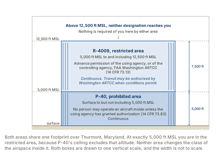
The chart prints the letter P and a number. Eleven prohibited areas are designated in the United States. P-40 lies over Camp David in Maryland, designated from the surface up to but not including 5,000 feet MSL. P-56 lies over the District of Columbia in two separate sub-areas, each from the surface up to and including 18,000 feet MSL. Both are in effect continuously.
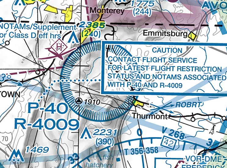
The using agency for a prohibited area is the agency, organization, or military command that established the requirements for the area (14 CFR 73.85). Part 73 gives no FAA facility the power to grant an authorization for a prohibited area. In the chart tabulation a prohibited area's row prints NO A/G in the CONTROLLING AGENCY/CONTACT FACILITY column, the abbreviation for no air to ground communications. A note on the tabulation sends you to a flight service station for information about the area. A flight service station is an air traffic facility that gives pilots preflight briefings and en route information by radio and telephone.
14 CFR 73.83, 73.85; AIM 3-4-2; PHAK Ch 15, "Prohibited Areas"
Restricted areas
A restricted area contains airspace within which the flight of aircraft, while not wholly prohibited, is subject to restrictions. Restricted areas denote the existence of unusual, often invisible, hazards to aircraft, such as artillery firing, aerial gunnery, or guided missiles. Penetrating one without authorization from the using or controlling agency may be extremely hazardous to the aircraft and its occupants (AIM 3-4-3).
The prohibition in the regulation carries two qualifiers. No person may operate an aircraft within a restricted area between the designated altitudes and during the time of designation, unless that person has the advance permission of the using agency described in 14 CFR 73.15 or the controlling agency described in 14 CFR 73.17 (14 CFR 73.13). Above the ceiling, below the floor, or outside the published hours, the area imposes no condition on your flight.
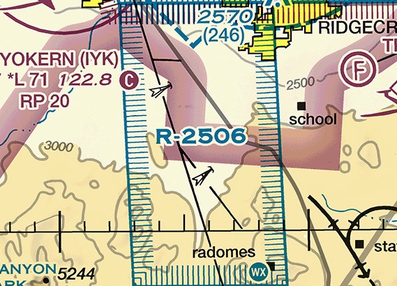
The chart prints the letter R and a number, in blue. Where an IFR route crosses a restricted area released for joint use, instrument flights may be authorized to transit it and are routed accordingly (AIM 3-4-3).
14 CFR 73.13; AIM 3-4-3; PHAK Ch 15, "Restricted Areas"
Using agency and controlling agency
14 CFR 73.13 names two authorities whose advance permission lets you into a restricted area.
The using agency is the agency, organization, or military command whose activity within the restricted area necessitated the area being so designated (14 CFR 73.15(a)). Three duties follow (14 CFR 73.15(c)):
- to schedule activities within the restricted area;
- to authorize transit through, or flight within, the restricted area as feasible;
- to contain within the restricted area all activities conducted there, in accordance with the purpose for which it was designated.
The controlling agency is the FAA facility that may authorize transit through or flight within a restricted area in accordance with a joint-use letter (14 CFR 73.17). An air traffic control (ATC) facility holds that role, usually an air route traffic control center (ARTCC). Upon the FAA's request the using agency executes a letter establishing procedures for joint use of the area, under which it notifies the controlling agency whenever that agency may grant permission for transit through the area (14 CFR 73.15(b)).
You can request the status of an area from either agency. The chart tabulates the controlling agency's frequency in its margin (AIM 3-4-9). You reach the using agency before the flight rather than from the cockpit.
14 CFR 73.13, 73.15, 73.17; AIM 3-4-9
Warning areas
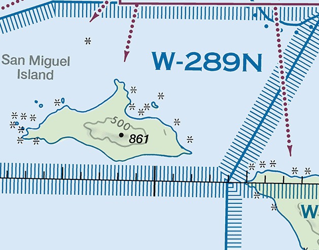
A warning area is airspace of defined dimensions, extending from three nautical miles outward from the coast of the United States, that contains activity that may be hazardous to nonparticipating aircraft. The purpose of such areas is to warn nonparticipating pilots of the potential danger. A warning area may be located over domestic or international waters or both (AIM 3-4-4).
The chart prints the letter W and a number, in blue. No regulation conditions your entry. The tabulation still gives the area's altitudes, its hours, and its controlling agency frequency.
AIM 3-4-4; PHAK Ch 15, "Warning Areas"
Military operations areas
An MOA consists of airspace of defined vertical and lateral limits established for the purpose of separating certain military training activities from IFR traffic. Whenever an MOA is being used, nonparticipating instrument flight rules (IFR) traffic may be cleared through it if IFR separation can be provided, and is otherwise rerouted or restricted (AIM 3-4-5). Nothing in that arrangement applies to a visual flight rules (VFR) flight, which may enter an active MOA legally and without asking anyone.
Examples of activities conducted in MOAs include air combat tactics, air intercepts, aerobatics, formation training, and low-altitude tactics (AIM 3-4-5). Two provisions that would otherwise constrain that flying are lifted inside an active MOA:
- Military pilots flying in an active MOA are exempted from 14 CFR 91.303(c) and (d), which prohibit aerobatic flight within the surface areas of Class B, Class C, Class D, or Class E airspace designated for an airport and within 4 nautical miles of the center line of any Federal airway. Both prohibitions still bind you. An earlier lesson covered them.
- The Department of Defense has been issued an authorization to operate aircraft at indicated airspeeds in excess of 250 knots below 10,000 feet MSL within active MOAs. The 250-knot limit of 14 CFR 91.117(a) still binds you.
The airplane you meet in an active MOA may therefore be maneuvering abruptly and faster than 250 knots at an altitude where you are held to 250. AIM 3-4-5 asks for two calls. They are:
- to any flight service station within 100 miles of the area, for real-time information on its hours of operation, because an MOA's activity status may change frequently;
- to the controlling agency, for traffic advisories, before entering an active one.
The chart prints the area's name followed by MOA rather than a number, in magenta.
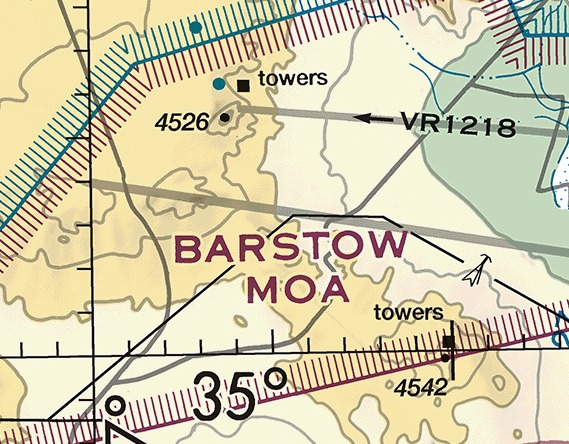
AIM 3-4-5; 14 CFR 91.303(c), 91.303(d), 91.117(a), 91.113(b); PHAK Ch 15, "Military Operation Areas (MOAs)"
Alert areas and controlled firing areas
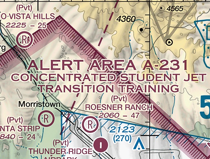
An alert area is depicted on aeronautical charts to inform nonparticipating pilots of areas that may contain a high volume of pilot training or an unusual type of aerial activity (AIM 3-4-6). All activity within an alert area must be conducted in accordance with the regulations, without waiver. Pilots of participating aircraft, as well as pilots transiting the area, must be equally responsible for collision avoidance.
The chart prints the letter A and a number, in magenta. In large areas the type of area is spelled out as well where space permits. Alert areas do not extend into Class A, Class B, Class C, or Class D airspace, or into Class E airport surface areas (FAA Aeronautical Chart Users' Guide).
A controlled firing area contains activities that, if not conducted in a controlled environment, could be hazardous to nonparticipating aircraft. Its distinguishing feature, compared with every other kind of special use airspace, is that its activities are suspended immediately when spotter aircraft, radar, or ground lookout positions indicate an aircraft might be approaching the area (AIM 3-4-7).
A controlled firing area is therefore not drawn on any chart. The activity stops when you approach, so the area never causes a nonparticipating aircraft to change its flight path. There is nothing left for the chart to warn you about (AIM 3-4-7; FAA Aeronautical Chart Users' Guide).
AIM 3-4-6, 3-4-7; PHAK Ch 15, "Alert Areas" and "Controlled Firing Areas (CFAs)"; FAA Aeronautical Chart Users' Guide, "Special Use Airspace"
Reading altitudes, hours, and the frequency to call
Every permanent special use airspace area except a controlled firing area is charted (AIM 3-4-1). On the map face the chart gives an area's type and its identifying name or number, positioned within or immediately adjacent to the area (FAA Aeronautical Chart Users' Guide). Its altitudes, its hours, its controlling agency, and the frequency to call sit in a tabulation printed in the chart margin.
Areas are shown in their entirety within the limits of the chart, even when they overlap, adjoin, or when one is designated within another (FAA Aeronautical Chart Users' Guide).
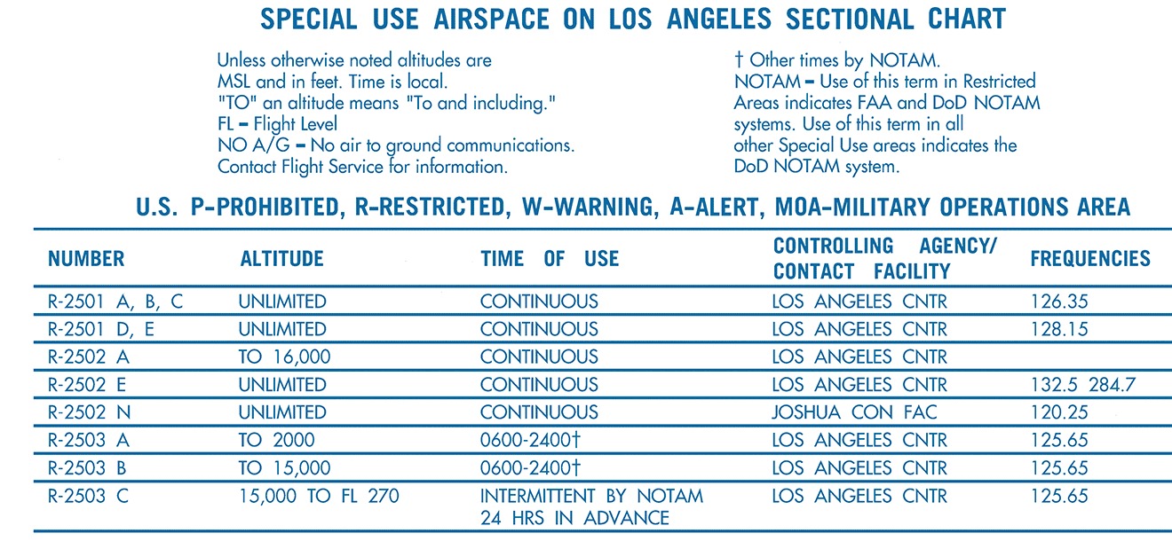
Six printed notes govern how the numbers are read:
- "Unless otherwise noted altitudes are MSL and in feet. Time is local."
- "'TO' an altitude means 'To and including.'"
- "FL - Flight Level"
- "NO A/G - No air to ground communications. Contact Flight Service for information."
- "† Other times by NOTAM."
- "NOTAM - Use of this term in Restricted Areas indicates FAA and DoD NOTAM systems. Use of this term in all other Special Use areas indicates the DoD NOTAM system."
In the last of those notes, DoD is the Department of Defense. The second of them restates a regulation: unless otherwise specified, the word "to" an altitude or flight level means "to and including" that altitude or flight level (14 CFR 73.3(b)). A ceiling written TO 6000 includes 6,000 feet MSL, so an airplane level at exactly 6,000 feet is inside the area.
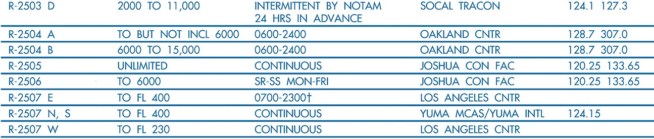
Take R-2506, the area drawn on the map face earlier in this lesson. Its row is the fifth in the strip above: TO 6000, SR-SS MON-FRI, JOSHUA CON FAC, 120.25 133.65. Read against the panel notes, that row gives four things:
- Altitudes. Surface up to and including 6,000 feet MSL. No floor is printed, so the floor is the surface. The 6,000 is an altitude above mean sea level, read on the altimeter, not a height above the ground.
- Time of use. Sunrise to sunset, Monday through Friday, in local time. Outside those hours 14 CFR 73.13 imposes nothing, because its prohibition runs only during the time of designation.
- Controlling agency. The Joshua Control Facility, an FAA facility holding a joint-use letter for the area.
- Frequencies. 120.25 or 133.65, to ask that facility for the area's status or for permission to transit it.
Crossing that area at 8,500 feet MSL on a Tuesday afternoon requires nothing of you, because you are 2,500 feet above the ceiling. Crossing it at 5,500 feet in the same hour requires the advance permission of the using agency or of the Joshua Control Facility.
The chart does not give you three things. A preflight has to establish each of them:
- Whether an area is active now. An airspace NOTAM is issued for special use airspace when its activation requires one, and the status is otherwise obtained from the using or controlling agency (AIM 3-4-1, 3-4-9). A row reading CONTINUOUS needs no such check.
- That temporary areas exist. Temporary restricted areas and temporary military operations areas are not charted, and neither are controlled firing areas (AIM 3-4-1).
- What lies above 18,000 feet MSL. A sectional shows only the airspace effective below that altitude (FAA Aeronautical Chart Users' Guide), so an area whose floor is higher is absent from the sheet.
14 CFR 73.3(b), 73.13; AIM 3-4-1, 3-4-9; FAA Aeronautical Chart Users' Guide, "Special Use Airspace" and "Airspace Information"
What the last lesson of this unit adds
One lesson remains in this unit. It covers the fourth type of airspace, the other airspace areas. It takes:
- temporary flight restrictions, and the NOTAM system that publishes every one of them;
- military training routes, whose centerlines cross the restricted area shown earlier in this lesson;
- terminal radar service areas;
- national security areas;
- air defense identification zones and the Defense VFR flight plan;
- published VFR routes;
- the special flight rules areas, including the one charted around Los Angeles International.
Four questions have to be answered on the ground before a route crosses special use airspace. They are:
- which areas the course line crosses, read off the map face by type and designation;
- what their floors, ceilings, and hours are, read out of the margin tabulation;
- which of them are prohibited or restricted, where entry is a regulatory matter rather than a judgment call;
- which of them are active today, which the chart cannot tell you and the controlling agency can.
An area whose ceiling is 6,000 feet MSL is crossed lawfully at 8,500 feet with no call made. An MOA is crossed lawfully at any altitude, and is still airspace where a military airplane may be maneuvering at more than 250 knots while you are held to 250.
Check your understanding
Answer from memory, without scrolling back up. Recalling it yourself is what makes it stick.
Which special use airspace areas are regulatory, established through rulemaking?
Part 73 designates restricted areas in subpart B and prohibited areas in subpart C, and those two alone are regulatory. (14 CFR 73.1; AIM 3-4-1)
Warning areas, military operations areas, alert areas, and controlled firing areas are nonregulatory. Part 73 reaches only the other two.
Flight inside a prohibited area requires which of the following?
No person may operate an aircraft within a prohibited area unless authorization has been granted by the using agency, the agency that established the requirements for it. (14 CFR 73.83, 73.85)
A controlling agency is the FAA facility that may authorize transit through a restricted area under a joint-use letter. A prohibited area has none: its tabulation row prints NO A/G in the CONTROLLING AGENCY/CONTACT FACILITY column.
Flight inside a restricted area during its hours of use requires which of these?
No person may operate within a restricted area between the designated altitudes and during the time of designation without the advance permission of the using or the controlling agency. (14 CFR 73.13, 91.133(a))
The regulation names two authorities and either one will do. Where the area is released for joint use, the FAA controlling agency named in the tabulation can grant it.
A restricted area's ceiling is 6,000 feet MSL. Crossing it at 8,500 feet, you need?
The prohibition in 14 CFR 73.13 applies only between the designated altitudes and during the time of designation. Above the ceiling the area imposes no condition on your flight.
A restricted area has a designated floor and ceiling, and its boundary does not continue above the ceiling printed in the tabulation.
A warning area is airspace of defined dimensions extending outward from where?
A warning area extends from three nautical miles outward from the coast of the United States and contains activity that may be hazardous to nonparticipating aircraft. Its purpose is to warn. (AIM 3-4-4)
The figure of three is a distance from the coast, not an altitude and not a buffer around another area. The United States government does not have sole jurisdiction over the airspace a warning area occupies.
A VFR flight approaching an active military operations area may do what?
No regulation bars a VFR flight from an active MOA. AIM 3-4-5 asks you to call a flight service station within 100 miles for the hours of operation, and the controlling agency for advisories before entering.
An MOA is nonregulatory, so no permission is required from anyone. What the AIM asks for is a call for information, not for authorization.
Inside an alert area, responsibility for collision avoidance rests with whom?
All activity within an alert area is conducted in accordance with the regulations without waiver, and participating and transiting pilots are equally responsible for collision avoidance. (AIM 3-4-6)
Nothing inside an alert area is exempt from the regulations, and no agency assumes the avoidance duty. The rule places it on every pilot in the area alike.
Why is a controlled firing area not depicted on any aeronautical chart?
The activity is suspended immediately when spotter aircraft, radar, or ground lookout positions indicate an aircraft might be approaching, so the area never causes a nonparticipating aircraft to change its flight path. (AIM 3-4-7)
The reason is the suspension of the activity. Because your flight path never has to change, the chart has nothing to warn you about and carries no symbol.
The tabulation gives a restricted area's altitude as TO 6000. That means?
Unless otherwise specified, "to" an altitude means "to and including" it, and the panel's note states that altitudes are MSL and in feet. (14 CFR 73.3(b))
Where a ceiling excludes the stated altitude, the tabulation prints TO BUT NOT INCL and the figure. A plain TO includes it, and the figure is an MSL altitude.
The frequency for a restricted area's controlling agency is found where?
The frequency for the controlling agency is tabulated in the margins of the applicable charts, beside the agency's name. (AIM 3-4-9)
The map face gives the area's type and its identifying name or number. Every number belonging to it, the frequency included, is in the margin tabulation.
Go deeper (primary source): read 14 CFR part 73 end to end and notice that 73.13 and 73.83 are each a single sentence. Then read AIM Section 3-4 from 3-4-1 through 3-4-7 and mark which paragraphs cite a regulation and which do not.