Private Pilot · Unit 5 · 25 min
Class E, Class G, and Airspace Requirements
By the end of this lesson you will know:
- every floor Class E can have, from the surface to 14,500 feet MSL, and what puts it there
- what a Federal airway is, how wide a Victor airway is, and where its base sits
- how thick the Class G is beneath each Class E floor
- which airspace requires a transponder with Mode C and which requires ADS-B Out
- how each class boundary is drawn on a sectional chart, and which side of a graded band carries the floor it marks
Class E: every floor it can have
Class E airspace is all the controlled airspace that is not Class A, Class B, Class C, or Class D, the four classes covered in The Airspace System at a Glance. It is the largest class by volume, and it is where most of a cross-country flight happens. Entering it under visual flight rules (VFR) requires no air traffic control (ATC) clearance and no radio call. Its floor is what you have to locate, because the floor sets whether Class E or Class G weather minimums apply to you at your altitude.
Two altitude references run through the Class E floors in this section, both set out in the previous lesson. They are:
- Mean sea level (MSL), the reference your altimeter indicates against once the current reported setting is dialed in. An MSL floor is printed on the FAA VFR Sectional Aeronautical Chart, called a sectional, as a number you can compare directly with the altimeter.
- Above ground level (AGL), a height measured from the terrain directly beneath you. An AGL floor is marked on the sectional with a graded band of color rather than a number.
The purpose of a given area is what sets where its floor sits.
The surface area
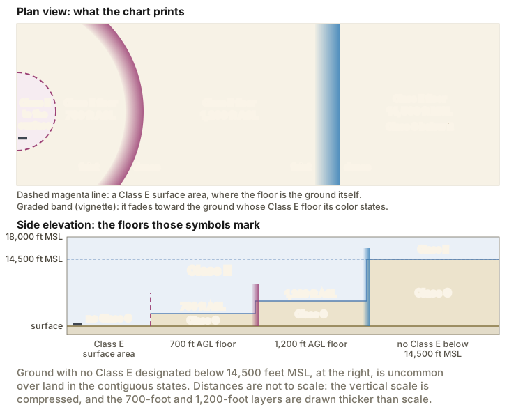
A Class E surface area extends from the surface up to a designated altitude or to the overlying controlled airspace, and it is configured to contain the instrument procedures at that airport. It is designated for an airport where a control tower is not in operation. To qualify, the airport must have weather observation and reporting capability, and communications capability with aircraft down to the runway surface. A Class E surface area is also what a part-time Class C or Class D surface area may become when the tower closes.
The point of a surface area is that instrument traffic descending to the runway stays inside controlled airspace all the way down. Because Class E imposes no communication requirement on VFR pilots, you may fly through one without talking to anyone, as long as you meet the Class E weather minimums.
Extensions to a surface area
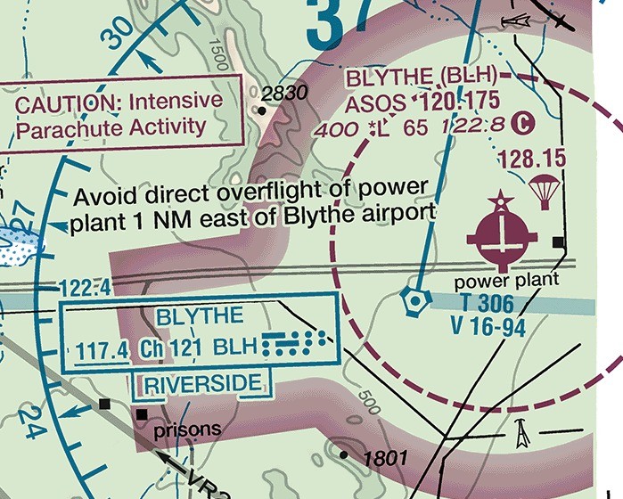
Class E airspace may also be designated as an extension to a Class B, Class C, Class D, or Class E surface area. An extension begins at the surface and reaches up to the overlying controlled airspace. Extensions exist to hold a standard instrument approach procedure inside controlled airspace without imposing a communications requirement on VFR pilots. If every extension at a Class D airport is 2 miles or shorter, all of them stay part of the Class D surface area. If any one extension is longer than 2 miles, all of that airport's extensions become Class E. Extensions are effective during the same hours as the surface area they belong to.
The 700-foot AGL floor
Where an airport has an approved instrument approach procedure, Class E is designated downward to 700 feet above the surface around it. The purpose is the same as a surface area's, one step higher: an arriving aircraft on the approach enters controlled airspace 700 feet above the ground rather than at 1,200 feet. The 700-foot floor is in effect continuously, whatever the airport's operating hours and whatever the surface area is doing.
On a sectional the lateral limit of that area is printed as a broad magenta band called a vignette, graded across its width from faint on one side to dense on the other. In the symbology of the FAA Aeronautical Chart Users' Guide, the faint side faces the ground where the Class E floor is 700 feet above the surface. The dense edge faces the ground beyond it, where the floor is higher.
The 1,200-foot AGL floor
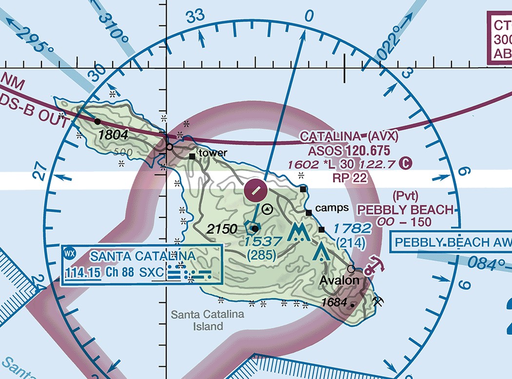
Class E is designated from 1,200 feet above the surface for the purpose of transitioning aircraft to and from the terminal or en route environment. Where such an area is designated along an airway or route, it has the same lateral extent as a Federal airway. Unless a different figure is specified, these areas run from 1,200 feet or higher above the surface up to but not including 14,500 feet MSL (14 CFR 71.71(c)).
Class E is also designated in en route domestic areas, which provide controlled airspace where the airway system does not reach. They carry the same 1,200-foot floor, and they cover most of the land area of the contiguous states (14 CFR 71.71(e)). The chart prints nothing to mark that coverage.
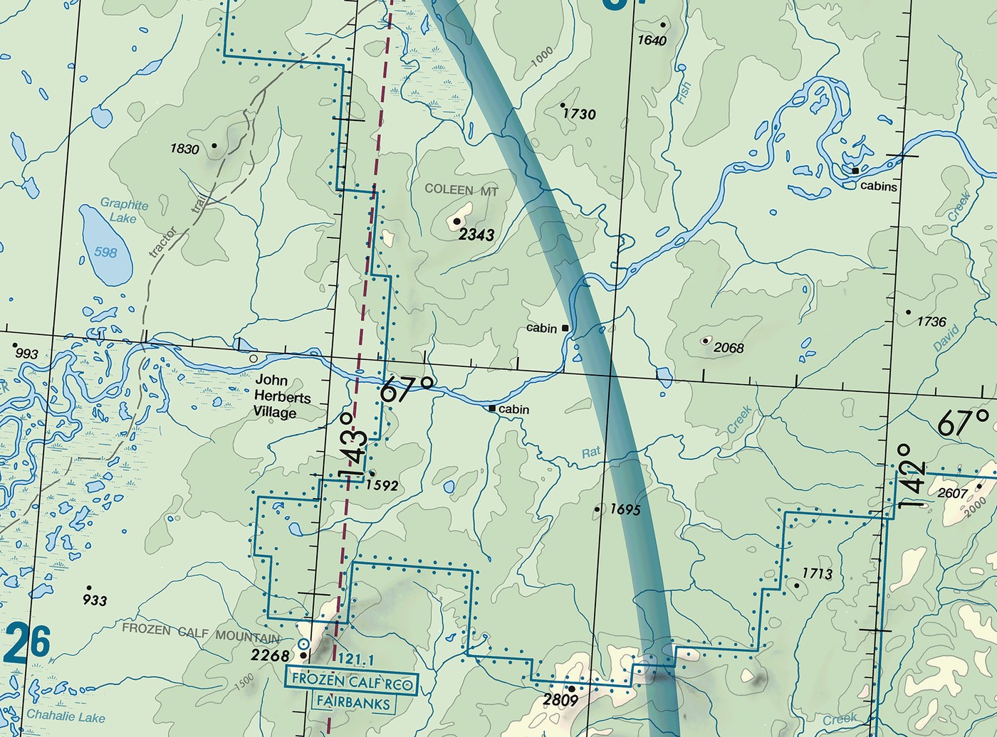
A blue vignette is printed where an area with a 1,200-foot floor reaches its lateral limit against Class G. The faint side of that band faces the ground where the Class E floor is 1,200 feet above the surface. The dense edge faces the ground beyond it, which has no Class E below 14,500 feet MSL.
Floors at a charted MSL altitude
Some Class E areas begin at an altitude printed on the chart in MSL rather than at a height above the ground. The FAA Aeronautical Chart Users' Guide gives a distinct symbol for a floor greater than 700 feet above the surface, and the floor altitude is printed next to it. That number gives the Class E floor for the area it labels, in place of the 700-foot or 1,200-foot AGL floor you would otherwise assume.
The 14,500-foot layer
Where nothing lower has been designated, Class E begins at 14,500 feet MSL and reaches up to but not including 18,000 feet MSL, over the 48 contiguous states, the District of Columbia, and Alaska, including the waters within 12 nautical miles of the coast. Two exclusions apply: the Alaska peninsula west of longitude 160 degrees West, and the airspace below 1,500 feet above the surface of the earth (14 CFR 71.71(a)). That second exclusion is the reason Class G can exist above 14,500 feet MSL. Over terrain higher than 13,000 feet, where no lower floor has been designated, the first 1,500 feet above the ground is still uncontrolled.
The ceiling, and what is above it
Class E stops below Class A: it extends up to but not including 18,000 feet MSL. Where a particular Class E area has a ceiling lower than 18,000 feet MSL, the chart prints the word CEILING and the altitude along the limits of that airspace. Above Class A, meaning above flight level (FL) 600, which is 60,000 feet, the airspace is Class E again (14 CFR 71.71(a)).
14 CFR 71.71; PHAK Ch 15, "Class E Airspace"; AIM 3-2-5, 3-2-6; FAA Aeronautical Chart Users' Guide, "Airspace"
Class E on the airways and out to sea
Three more designations are Class E. They are:
- Federal airways. The Federal airways are Class E airspace (14 CFR 71.71(d)). Unless otherwise specified, they extend from 1,200 feet AGL up to but not including 18,000 feet MSL. A VOR Federal airway, spoken as a Victor airway, is identified by the letter V followed by a number, as in V137. Its centerline runs between VHF omnidirectional range (VOR) and VHF omnidirectional range/tactical air navigation (VORTAC) stations, which are ground radio navigation stations that a receiver in the airplane tracks. Navigating by them is the subject of Unit 10. A Victor airway is 8 nautical miles wide, 4 nautical miles either side of the centerline (FAA Order JO 7400.2R, paragraph 20-3-3). The other Federal airways are the colored airways. Their centerlines run between nondirectional beacons, an older type of ground radio beacon. A colored airway is identified as green, red, amber, or blue, and it is charted on an IFR en route low altitude chart rather than on a sectional.
- En route domestic areas. These are Class E areas that provide controlled airspace where en route service under instrument flight rules (IFR) must be available but the airway system does not reach. Each one has the same lateral extent as a Federal airway and runs from 1,200 feet above the surface up to the overlying or adjacent controlled airspace (14 CFR 71.71(e)).
- Offshore airspace areas. These provide controlled airspace beyond 12 nautical miles from the coast where IFR en route service is required and the United States applies domestic procedures. Each extends from a specified altitude up to but not including 18,000 feet MSL (14 CFR 71.71(f)).
Of these three, only the Victor airways are drawn on a sectional, as a centerline with the airway identifier beside it. En route domestic areas and offshore airspace areas matter to an IFR flight plan rather than to a VFR chart.
Federal airways are also what the aerobatic-flight rule measures from. No person may operate an aircraft in aerobatic flight within 4 nautical miles of the centerline of any Federal airway (14 CFR 91.303(d)).
14 CFR 71.13, 71.71, 91.303; AIM 3-2-6, 5-3-4; FAA Order JO 7400.2R, paragraph 20-3-3
Class G
Class G airspace is the portion of the airspace that has not been designated as Class A, B, C, D, or E. It extends from the surface up to the base of the overlying Class E. The chart markings around a piece of ground tell you how thick the Class G above it is:
- under a Class E surface area, there is no Class G at all;
- on the faint side of a magenta vignette, the first 700 feet above the ground;
- on the faint side of a blue vignette, the first 1,200 feet above the ground;
- over ground in the contiguous states with no boundary printed on it, the first 1,200 feet above the ground;
- where no Class E has been designated lower, everything below 14,500 feet MSL (14 CFR 71.71(a)).
Over land in the contiguous states that last case is rare. The en route domestic areas of 14 CFR 71.71(e) put a 1,200-foot floor over most of that land. Class G reaching 14,500 feet MSL is found offshore beyond the limit of those areas and over parts of interior Alaska.
ATC has no authority or responsibility to control air traffic in Class G, and no separation service is provided there. Two requirements still apply in Class G. They are:
- your duty to see and avoid other aircraft, which applies wherever weather conditions permit (14 CFR 91.113(b));
- the Class G minimum flight visibility and distance from clouds, which vary with altitude and with day or night (14 CFR 91.155).
An airport in Class G may still have a control tower. When a tower is in operation, no person may operate to, from, through, or on that airport unless two-way radio communications are maintained with the tower (14 CFR 91.126(d)). Communications must be established prior to 4 nautical miles from the airport, up to and including 2,500 feet AGL. That is a rule about the tower, not about the airspace, and it applies the same way at an airport in Class E (14 CFR 91.127(c)).
Class G has no symbol of its own on a chart. Its top is read from the symbol that borders it.
14 CFR 71.71, 91.126, 91.127; PHAK Ch 15, "Uncontrolled Airspace"; AIM 3-3-1
What each class requires of you
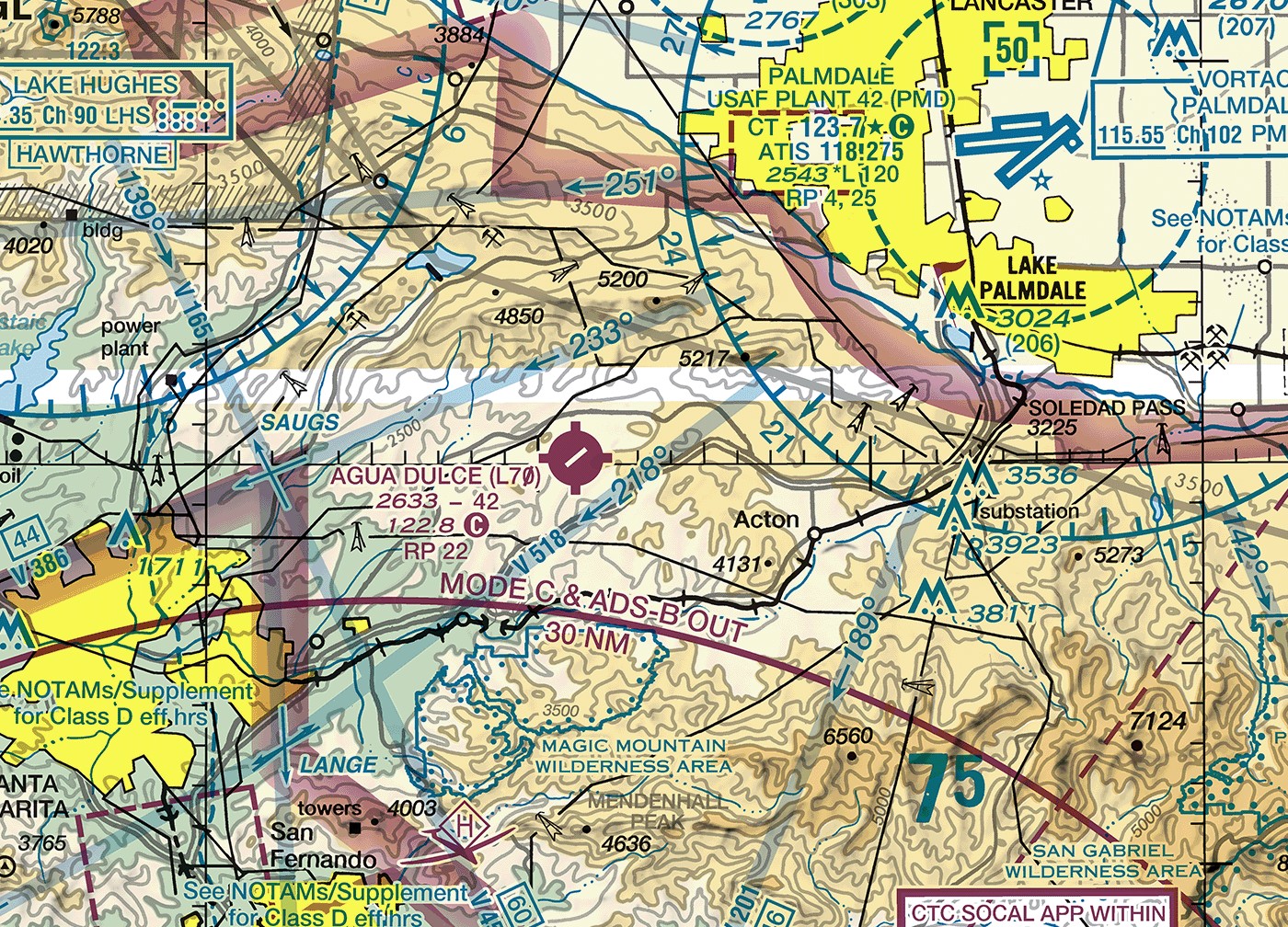
A transponder is a radio that answers an ATC radar interrogation with a coded reply, so the aircraft appears on the controller's display with an identity attached. Mode C is the added capability to report pressure altitude automatically in 100-foot increments, which is what puts an altitude readout beside your aircraft on that display. Automatic Dependent Surveillance-Broadcast (ADS-B) Out broadcasts the aircraft's position, altitude, and velocity, derived from satellite navigation, to ground stations and to nearby aircraft. A Mode C veil is the airspace within 30 nautical miles of an airport listed in appendix D section 1 to Part 91, from the surface up to 10,000 feet MSL (14 CFR 91.215(b)(2)).
| Class | Entry requirement | Equipment | Minimum pilot qualification |
|---|---|---|---|
| A | ATC clearance, IFR only | IFR equipped, transponder with Mode C, ADS-B Out | Private certificate plus instrument rating |
| B | ATC clearance | Two-way radio, transponder with Mode C, ADS-B Out | Private, with limited student, sport, and recreational provisions |
| C | Two-way radio communications established before entry | Two-way radio, transponder with Mode C, ADS-B Out | No specific requirement |
| D | Two-way radio communications established before entry | Two-way radio | No specific requirement |
| E | None for VFR | No specific requirement below 10,000 ft MSL | No specific requirement |
| G | None | No specific requirement below 10,000 ft MSL | No specific requirement |
The equipment column gives what the class itself requires. Inside a Mode C veil, and above the ceiling of a Class B or Class C area up to 10,000 feet MSL, a transponder with Mode C and ADS-B Out are required in Class E and Class G as well (14 CFR 91.215(b), 91.225(d)).
A transponder with Mode C is required in the following airspace (14 CFR 91.215(b)):
- Class A, Class B, and Class C airspace areas;
- all airspace within 30 nautical miles of an airport listed in appendix D section 1 to Part 91, from the surface up to 10,000 feet MSL, which is the Mode C veil;
- all airspace above the ceiling of, and within the lateral boundaries of, a Class B or Class C area, up to 10,000 feet MSL;
- all airspace of the 48 contiguous states and the District of Columbia at and above 10,000 feet MSL, excluding the airspace at and below 2,500 feet above the surface.
ADS-B Out is required in Class A (14 CFR 91.225(a)) and in the following airspace below 18,000 feet MSL (14 CFR 91.225(d)):
- Class B and Class C airspace areas;
- within 30 nautical miles of an appendix D section 1 airport, from the surface up to 10,000 feet MSL;
- above the ceiling of, and within the lateral boundaries of, a Class B or Class C area, up to 10,000 feet MSL;
- Class E airspace within the 48 contiguous states and the District of Columbia at and above 10,000 feet MSL, excluding the airspace at and below 2,500 feet above the surface.
The two lists differ in one respect. The transponder rule covers all airspace at and above 10,000 feet MSL; the ADS-B Out rule covers Class E airspace at and above that altitude. Neither rule is waived for Class A, Class B, or Class C. An aircraft never certificated with an engine-driven electrical system, and any balloon or glider, may fly inside the 30 nautical mile veil without a transponder or ADS-B Out only while it stays outside Class A, Class B, and Class C and below the lower of the Class B or Class C ceiling or 10,000 feet MSL (14 CFR 91.215(b)(3), 91.225(e)). The same aircraft are exempt outright from the requirement at and above 10,000 feet MSL (14 CFR 91.215(b)(5), 91.225(e)).
The airworthiness lesson covered the maintenance side of this equipment: a transponder must have been tested and inspected within the preceding 24 calendar months before it may be used (14 CFR 91.413(a)). An airplane can have a transponder installed and still be unable to enter Class C legally if that test has lapsed.
14 CFR 91.215, 91.225; PHAK Ch 15, Figure 15-9 and "Operating Rules and Pilot/Equipment Requirements"
How the boundaries are drawn on a chart
Blue marks Class B and Class D. Magenta marks Class C and Class E. A thick solid line marks Class B or Class C. A dashed line marks Class D or a Class E surface area.
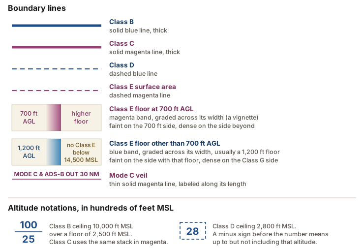
A few reading rules go with the symbols:
- Class B and Class C altitudes are printed as a stacked pair, ceiling over floor, in hundreds of feet MSL. SFC in place of the lower number means the floor is the surface. A plus sign before a Class B floor means the airspace begins above that altitude.
- A Class D ceiling appears alone inside a dashed blue box. A minus sign before the number means the airspace goes up to but not including that altitude.
- A vignette is graded across its width. The faint side faces the ground whose Class E floor its color states: 700 feet AGL for magenta, and for blue the floor stated alongside the band, which is 1,200 feet AGL where no number is printed. The dense edge faces the ground on the other side, which has a higher floor or has no Class E below 14,500 feet MSL.
- A dashed magenta line encloses a Class E surface area, where the floor is the ground itself.
- Over most of the contiguous United States, ground with no boundary printed on it has a Class E floor at 1,200 feet AGL.
- Where a Class E ceiling is below 18,000 feet MSL, the chart prints the word CEILING and the altitude along that limit.
- The Mode C veil is the only equipment boundary drawn on the chart.
The rest of the sectional legend belongs to the chart-reading lesson in Unit 6.
FAA Aeronautical Chart Users' Guide, "Airspace" and "Airspace Information"
What the rest of this unit adds
Two subjects remain in this unit:
- the flight visibility and distance-from-cloud minimums for each class, and the special VFR clearance that can substitute for them, come in the next lesson;
- the special use airspace areas and the other airspace areas come in the two lessons after that.
Check your understanding
Answer from memory, without scrolling back up. Recalling it yourself is what makes it stick.
Flying VFR through a Class E surface area at a nontowered airport requires?
Class E imposes no communication requirement on VFR pilots, so you may fly through a surface area without talking to anyone. (AIM 3-2-6)
Established communications is the entry condition for Class C and Class D, and a clearance for Class B. Class E requires neither, even where it reaches the surface.
A magenta vignette rings an airport and fades toward it. Inside the ring the Class E floor is?
A magenta vignette marks a Class E floor at 700 feet above the surface (AIM 3-2-6). The band fades toward the ground that carries that floor (FAA Aeronautical Chart Users' Guide).
The faint side of the band is the side with the floor the color names, and that height is measured above the ground rather than above sea level.
Class E airspace has a ceiling at?
Class E reaches up to but not including 18,000 feet MSL, where Class A begins, and the airspace above FL600 is Class E again. (14 CFR 71.71(a))
The ceiling is 18,000 feet MSL and that altitude itself is Class A. Above FL600, where Class A ends, the airspace returns to Class E.
A VOR Federal airway such as V137 is Class E airspace that is?
A Victor airway is 8 nautical miles wide, 4 nautical miles either side of the centerline, and unless otherwise specified it runs from 1,200 feet AGL to below 18,000 feet MSL. (14 CFR 71.71(d); FAA Order JO 7400.2R, paragraph 20-3-3)
The 4 nautical miles is the half width, measured from the centerline out to each edge, so the airway is 8 nautical miles across. Its base is 1,200 feet AGL.
On a sectional of the contiguous states, ground with no boundary printed on it normally has?
The en route domestic areas of 14 CFR 71.71(e) put a 1,200-foot AGL floor over most of the land in the contiguous states, and no boundary is printed inside that coverage.
Class E at 14,500 feet MSL is what the regulation provides where nothing lower is designated (14 CFR 71.71(a)), and over land it is rare. Ground with a 700-foot floor is bounded by a magenta vignette rather than left blank.
A transponder with Mode C is required within 30 nautical miles of certain airports from?
The Mode C veil covers all airspace within 30 NM of an appendix D section 1 airport, from the surface up to 10,000 feet MSL. (14 CFR 91.215(b)(2))
The veil starts at the surface, not at 1,200 feet AGL, and it tops out at 10,000 feet MSL. It is drawn on the chart as a thin magenta ring.
A Class D airport has one arrival extension 3 miles long and one 1 mile long. They are?
If any one extension is longer than 2 miles, all of that airport's extensions become Class E. (AIM 3-2-5)
The rule reads the longest extension and then applies to every extension at that airport. Only where all of them are 2 miles or shorter do they stay Class D.
In Class G at 12,000 feet MSL, more than 2,500 feet above the surface, you need?
The transponder rule reaches all airspace at and above 10,000 feet MSL (14 CFR 91.215(b)(5)(i)); the ADS-B Out rule reaches only Class E at that altitude (14 CFR 91.225(d)(4)).
This altitude is the one place the two lists diverge. The transponder rule names all airspace, and the ADS-B Out rule names Class E airspace.
Class G can reach above 14,500 feet MSL because that Class E layer excludes?
The 14,500-foot layer excludes the airspace below 1,500 feet above the surface, so over terrain higher than 13,000 feet that first 1,500 feet stays Class G where nothing lower is designated. (14 CFR 71.71(a))
The exclusion is 1,500 feet above the surface. The 1,200-foot figure is a designated Class E floor, and 2,500 feet appears in the transponder rule.
On a sectional, a thick solid magenta line and a dashed blue line mark?
Thick solid magenta is Class C and dashed blue is Class D. (FAA Aeronautical Chart Users' Guide, "Airspace")
Thick solid blue marks Class B and dashed magenta marks a Class E surface area, so neither of those is the pair described.
Go deeper (primary source): read 14 CFR 71.71 for every designation of Class E airspace, then 14 CFR 91.215 and 91.225 for the transponder and ADS-B Out rules. Then read AIM 3-2-6 on Class E and AIM 3-3-1 on Class G.