Private Pilot · Unit 7 · 30 min
The Atmosphere and Pressure
By the end of this lesson you will know:
- what dry air is made of, and which of its gases varies enough to produce weather
- which layer of the atmosphere holds almost all weather, and how high its upper boundary sits
- how the sun heats the air, why that heating is uneven, and what a thermal is
- what a lapse rate is, what an inversion is, and the conditions that produce one at the surface
- what atmospheric pressure is, how a barometer measures it, and why station pressures are reduced to sea level
- why a cold column of air holds a given pressure closer to the ground than a warm column does
Weather is the state of the atmosphere at any given time and place. A layer of fog, a line of thunderstorms, ice accreting on a wing, and a headwind that costs you an hour are all consequences of how a few properties of the air are arranged that day: its temperature, its pressure, its density, and how much water vapor it holds.
This lesson covers the air itself, before any of the weather that happens in it. It covers what the atmosphere is made of, how it is layered, how the sun heats it, how temperature varies with height, what atmospheric pressure is, how it is measured, and why a warm column of air and a cold column of air do not hold a given pressure at the same height.
What the air is made of
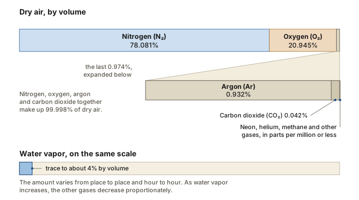
Dry air is a mixture of gases in nearly fixed proportions. Nitrogen accounts for 78.081 percent by volume and oxygen for 20.945 percent, so those two alone are 99.03 percent of it. Argon adds 0.932 percent and carbon dioxide 0.042 percent, and those four gases together make up 99.998 percent of dry air. The rest is neon, helium, methane, krypton and nine other gases, each present in parts per million or less. Nitrogen dilutes oxygen and prevents rapid burning at the Earth's surface. Oxygen is used by all living things and is essential for respiration. Carbon dioxide also acts as a blanket and prevents the escape of heat to outer space.
None of those proportions changes enough from day to day to make weather. The constituent that does is water vapor, which the dry-air percentages above leave out. The atmosphere always contains some water vapor, in amounts varying from trace to about 4 percent by volume, and as water vapor content increases the other gases decrease proportionately. Approximately half of all the atmospheric water vapor sits below 2 kilometers, about 6,500 feet, which is the altitude band a trainer spends most of its life in. Water vapor is the raw material of every cloud, every fog bank and every icing encounter. What governs how much of it the air can hold, and what happens when it can hold no more, is the subject of the lesson on clouds, stability and fog later in this unit.
Reasoning about the whole atmosphere at once is impractical, so meteorology works with a small sample of it instead. An air parcel is an imaginary volume of air to which any or all of the basic properties of atmospheric air may be assigned. It is large enough to contain a very large number of molecules but small enough that the properties assigned to it are approximately uniform, so it has one temperature, one pressure, one density and one water vapor content rather than a range of each. The definition carries no fixed size, though a cubic centimeter of air might fit most contexts where parcels are discussed.
Aviation Weather Handbook (FAA-H-8083-28B) Ch 4, "Composition" and "Air Parcel"; Ch 6, "Introduction"
The layers of the atmosphere
The atmosphere extends from the surface out many thousands of miles, becoming thinner with distance but always held by the Earth's gravitational pull. It is subdivided into five concentric layers, and the division is made on the vertical profile of average air temperature changes, chemical composition, movement and density. Each of the five layers is topped by a pause, a boundary at which the changes in those thermal, chemical and density characteristics are largest.
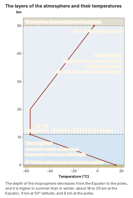
The troposphere is the bottom layer. It begins at the surface and extends up to about 11 kilometers, 36,000 feet. The air becomes thinner with height, and the temperature decreases with height as well: from about 15 degrees Celsius (59 degrees Fahrenheit) at the surface to about minus 56.5 degrees Celsius (minus 70 degrees Fahrenheit) at the top. Almost all weather occurs in this region.
That 36,000 feet is an average, and the real depth of the troposphere varies with latitude and season. It decreases from the Equator to the poles, and it is higher during summer than in winter. At the Equator it is around 18 to 20 kilometers (11 to 12 miles) high, at 50 degrees north and south latitude 9 kilometers (5.6 miles), and at the poles 6 kilometers (3.7 miles). Even the shallowest of those figures is far above the altitudes a trainer can reach, so every flight you make as a private pilot happens inside this layer.
The tropopause is the transition boundary between the troposphere and the layer above it, and the standard atmosphere places it at a pressure altitude of 36,089 feet with a temperature of minus 56.5 degrees Celsius. Above it lies the stratosphere, which extends from the tropopause up to 50 kilometers (31 miles). It holds 19 percent of the atmosphere's gases but very little water vapor. Temperature there increases with height, because radiation is increasingly absorbed by oxygen molecules, leading to the formation of ozone; the temperature rises from about minus 56.5 degrees Celsius at the tropopause to a maximum of about minus 3 degrees Celsius at the stratopause. That increasing temperature also makes it a calm layer, with movements of the gases being slow. Commercial aircraft often cruise in the lower stratosphere to avoid the turbulence and convection of the troposphere below. Three further layers, the mesosphere, the thermosphere and the exosphere, lie above the stratosphere, far above any weather this unit covers.
Aviation Weather Handbook Ch 4, "Introduction," "Vertical Structure," and Table 4-2
How the sun heats the air
The heat source for the surface of the Earth is the Sun, and heat transfer is energy transfer as a consequence of temperature difference. Heat always flows from the warmer body to the colder one, and where a temperature difference exists between objects in proximity, the transfer between them can never be stopped, only slowed down. Three mechanisms carry heat into and through the atmosphere: radiation, conduction and convection, singly or in combination.
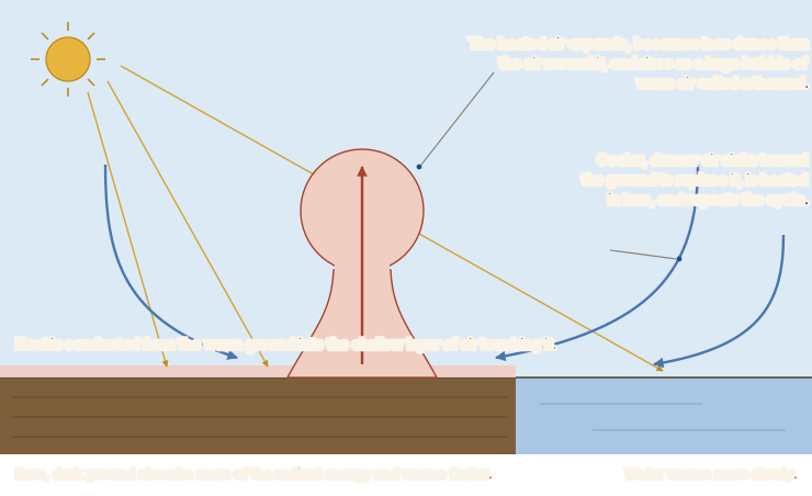
Radiation is the transfer of heat energy through space by electromagnetic waves, and it needs no air in between; it is what you feel on the side of your body facing a campfire. More of the solar radiation reaching the Earth is absorbed at the surface than is absorbed by the air on the way down, and some of what the surface absorbs is then radiated back into the atmosphere to become heat energy. Dark-colored objects such as asphalt absorb more of the radiant energy and warm faster than light-colored objects, and dark objects also radiate their energy faster. The consequence is that the atmosphere is heated chiefly from below, at the surface, rather than directly by the Sun on the way down.
Conduction is the transfer of energy by molecular activity from one substance to another in contact with it, and it is how the warm ground passes its heat to the air resting on it. It reaches only the shallow layer of air in contact with the ground, because air is a poor thermal conductor: its conductivity is 0.024 watts per meter-kelvin, against 0.17 to 1.13 for soil.
Convection is what carries the ground's heat higher. Convection is the transport of heat within a fluid by motions of the fluid itself, and because air is a poor thermal conductor, convection is much more important than conduction as a heat transport mechanism within the atmosphere. Incoming solar radiation heats the surface, and the heating is somewhat uneven, because certain areas of the surface absorb more heat from the Sun than others. Heat is conducted from the relatively warm ground to the cooler overlying air, which warms a shallow layer near the ground. The heated air expands, becomes less dense than the surrounding cooler air, and rises. A large bubble of warm air called a thermal lifts away from the surface and transfers heat energy upward. Cooler, denser air sinks toward the ground to replace the rising air, is heated in turn, rises, and repeats the cycle.
Two consequences of this cycle matter to a pilot. The first is that unevenness in the surface produces unevenness in the air above it, and that unevenness is what sets air in vertical motion. The second is timing. The incoming solar radiation peaks around noon, but the maximum surface air temperature usually occurs during the midafternoon, because the air near the ground needs that lag to heat up by conduction and convection with the surface. The minimum surface air temperature usually occurs shortly after sunrise, because the surface radiates heat away all night and only begins to warm again when the incoming solar radiation once more exceeds that outgoing radiation. The daily rhythm of thermals, of surface winds and of afternoon buildups follows that lag rather than the position of the Sun.
Aviation Weather Handbook Ch 5, "Heat Transfer"; Ch 7, "Sensible Heating" and "Diurnal Temperature Variation"
Temperature aloft: lapse rate and inversions
A lapse rate of temperature is a decrease in temperature with height. In the standard atmosphere the temperature decreases 6.5 degrees Celsius per 1,000 meters, which the handbook gives in English units as 3.57 degrees Fahrenheit per 1,000 feet, and which works out to just under 2 degrees Celsius per 1,000 feet. That figure is an average, and the exact value seldom exists. Temperature in the troposphere sometimes remains constant with height or even increases with height. The handbook adds a specific warning: caution should be taken when using the standard lapse rate to estimate the freezing level, because the layer nearest the ground quite often cools with height faster than the standard rate, and the estimate could be in error.
What the air is actually doing on a given morning is read from a sounding, a plot of the vertical profile of one or more atmospheric parameters, such as temperature, dewpoint or wind, above a fixed location. Two departures from a steady lapse show up on soundings often enough to have names. An isothermal layer is a layer within the atmosphere where the temperature remains constant with height. A temperature inversion is a layer in which the temperature increases with altitude, which is the reverse of the normal profile.
Where the base of the inversion is at the surface it is termed a surface-based inversion, and where the base is not at the surface it is termed an inversion aloft. A surface-based inversion typically develops over land on clear nights when wind is light. The ground radiates and cools much faster than the overlying air, so air in contact with the ground becomes cool while the temperature a few hundred feet above changes very little, and temperature therefore increases with height through the shallow layer between them. Clear skies allow for the most cooling to take place, since an overcast traps heat energy radiated by the Earth and keeps the air from cooling as much. A light wind leaves the chilled air in contact with the ground instead of mixing it upward. An inversion may also occur at any altitude when conditions are favorable, as when a current of warm air aloft overruns cold air near the surface. Inversions are common in the stratosphere.
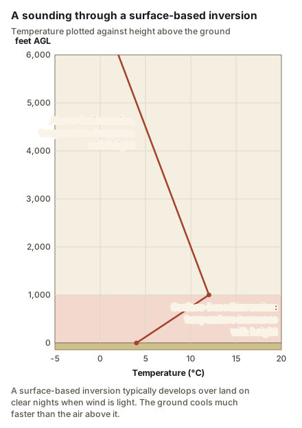
The principal characteristic of an inversion layer is its marked stability, so that very little turbulence can occur within it. That is why a dawn flight through a surface-based inversion is usually a smooth one. The stability is a property of the layer itself, though, not of its edges: strong wind shears often occur across temperature inversion layers, and those shears can generate turbulence. Turbulence in full, including the shear kind, is covered in the lesson on thunderstorms and icing that closes this unit.
Aviation Weather Handbook Ch 5, "Temperature Variations with Altitude," "Atmospheric Sounding," "Isothermal Layer," and "Temperature Inversion"; Ch 7, "The Earth-Atmosphere Energy Balance"; Ch 19, "Temperature Inversion"
What pressure is and how it is measured
The atoms and molecules that make up the atmosphere are always moving in random directions, and when they strike a surface they exert pressure. Each molecule is too small to feel and exerts only a tiny amount of it, but the total from the large number of molecules that strike a surface each moment is considerable. Because the molecules move in every direction, they exert that pressure in every direction, including upward against the underside of an object. As the density of the air increases, the number of strikes per unit of time and area increases with it.
Atmospheric pressure is the force per unit area exerted by the weight of the atmosphere. Air cannot be weighed on conventional scales because it is not solid, but in the seventeenth century Evangelista Torricelli proved he could weigh the atmosphere by balancing it against a column of mercury. That is also why a pressure is quoted in inches of mercury: the number is the height of the mercury column the air will support.
The instrument Torricelli designed is the barometer, and the aneroid type is the one most commonly used by meteorologists and the aviation community. Its essential features are a flexible metal cell and a registering mechanism. Air is taken out of the cell to create a partial vacuum, so the cell contracts or expands as the pressure around it changes. One end of the cell is fixed while the other end drives the registering mechanism, and the coupling magnifies the movement of the cell to drive an indicator hand along a scale graduated in pressure units. The altimeter described in the pitot-static lesson is an aneroid barometer whose scale is graduated in feet rather than in units of pressure.
The same pressure is reported in different units depending on who is reading it. The standard sea-level value in each of them is:
- Hectopascals (hPa), 1013.2 at sea level. The unit used in METAR and SPECI, the coded weather observations that are the subject of Unit 8.
- Millibars (mb), 1013.2 at sea level. The unit used on United States weather charts. One hectopascal equals one millibar exactly.
- Inches of mercury (inHg), 29.92 at sea level. The unit still used in the United States for altimetry, and the one you dial into the altimeter.
Pressure falls as you climb for the reason the definition implies: the weight of the air above you decreases. A barometer carried up a mountain measures that decrease directly.
Aviation Weather Handbook Ch 8, "Atmospheric Pressure," "Barometer," "Atmospheric Pressure Units," and "Pressure Changes with Altitude"
Station pressure and sea level pressure
The pressure measured at an airport is called station pressure, the actual pressure at field elevation. Because pressure is lower at higher altitudes, airports with higher field elevations usually have lower station pressures than airports with lower field elevations. Denver usually reads lower than New Orleans, and almost none of that difference is weather.
If one station reads 25 inches of mercury and another reads 30, you cannot tell from those two numbers whether a weather system sits between them, because the difference could be entirely a matter of how high the two barometers are. Since pressure varies greatly with altitude, station pressures at different altitudes cannot readily be compared. They are therefore adjusted to a common level, and mean sea level is the most useful common reference.
The adjustment uses the rate at which pressure changes with height near the surface, which is about 1 inch of mercury for each 1,000 feet. The handbook works one example through: a station at 5,000 feet elevation measures 25 inches of mercury, the 5,000 feet of elevation account for about 5 inches, and the sea level pressure is therefore approximately 25 plus 5, or 30 inches of mercury. Every station in the country is reduced the same way, and the reduced values are what appear on surface weather charts. Pressure continually changes across the Earth, so a sequence of surface charts has to be viewed to follow those changes rather than a single one.
Two things follow. The first is that the altimeter setting you dial into the Kollsman window has had this same reduction applied: the pitot-static lesson defined it as the local pressure corrected to sea level. The regulation that requires you to keep it current is covered in the operating rules lesson. The second is that once every station is reduced to the same reference, the differences that remain between one place and another are real differences in the atmosphere. Those differences are what set air in horizontal motion, and turning them into wind is the work of the next lesson in this unit.
Aviation Weather Handbook Ch 8, "Station Pressure" and "Sea Level Pressure"
Warm columns and cold columns
The rate of about 1 inch of mercury per 1,000 feet belongs to the standard atmosphere, and the standard atmosphere's altitudes are based on standard temperatures. In the real atmosphere temperatures are seldom standard, and temperature is what makes the actual rate differ. Like most substances, air expands as it becomes warmer and contracts as it cools. A column of air is therefore not a fixed object: warming it makes it taller without adding any air to it, and cooling it makes it shorter without taking any away.
Consider three columns of air standing on the same ground, one colder than standard, one at standard temperature and one warmer than standard, with the pressure equal at the bottom of each and equal at the top of each. Vertical expansion of the warm column has made it taller than the column at standard temperature, and contraction of the cold column has made it shorter than the standard column. The total pressure decrease from bottom to top is the same in all three, but that same decrease is spread over a greater height in the warm column and a smaller height in the cold one. The rate of decrease of pressure with height in warm air is therefore less than standard, and the rate of decrease of pressure with height in cold air is greater than standard.
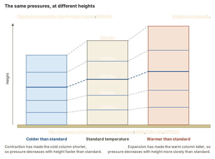
An altimeter is an aneroid barometer, so the altitude it indicates at the top of each of those three columns is the same, even though the three tops are at three different heights. Flying at a fixed indicated altitude means following a surface of constant pressure. In the warm column a pilot would be flying at a height greater than the indicated altitude. In the cold column a pilot would be flying at a height lower than the indicated altitude. The movable scale on the altimeter lets you adjust for the surface pressure beneath you, but there is no adjustment on the instrument for the mean temperature of the column of air below it.
That is the mechanism behind the memory aid the pitot-static lesson attached to the altimeter: from a high to a low, or from hot to cold, look out below. The pressure half of it is the same argument run horizontally, since flying toward lower pressure without resetting the window leaves the instrument reading a pressure level that has sunk toward the ground. The temperature half happens for the reason the columns show: cold air occupies less vertical space, so every pressure level in it, including the one the altimeter is tracking, sits closer to the terrain.
Aviation Weather Handbook Ch 8, "Pressure Changes with Altitude," "Temperature's Effects on Pressure," "Indicated Altitude," and "Altimeter Setting"
Air density and what changes it
Atmospheric density is the ratio of the mass of the air to the volume it occupies, usually expressed in kilograms per cubic meter. It is the property the airplane responds to most directly, because the lift the wing makes, the thrust the propeller produces and the power the engine develops all depend on the mass of air each is working with. For a parcel of a given mass, the smaller the volume the higher the density, because the same molecules are compressed into less space. Three quantities change it.
- Pressure. Density is directly related to pressure. At constant mass and temperature, a parcel at higher pressure is denser than one at lower pressure. Since pressure decreases with height, density decreases with height as well, and in the atmosphere pressure has the greatest effect on density in the vertical direction.
- Temperature. Density is inversely related to temperature. At constant mass and pressure, a parcel at a higher temperature is less dense than one at a lower temperature, because the warmer air occupies a larger volume. In the atmosphere temperature has the most effect on density in the horizontal direction, which is to say between one place and another at the same altitude.
- Water vapor. Density is inversely related to the quantity of water vapor. At constant pressure, temperature and volume, air with a greater amount of water vapor is less dense than air with less of it, because dry air molecules have a larger mass than water vapor molecules and density is directly related to mass.
So the air is thinnest when you are high, when it is hot, and when it is humid. Those three conditions arrive together on a summer afternoon at a mountain airport. The pitot-static lesson defined density altitude as pressure altitude corrected for nonstandard temperature, the altitude at which the air has the density the airplane is actually working in. That correction is necessary because density is not a quantity any instrument in the panel reports: it has to be computed from the pressure and the temperature that are reported. In that computation, temperature is the most important factor, because temperature has the greatest effect on density horizontally. Water vapor is also a contributing factor, but its effects are generally negligible. What high density altitude does to takeoff distance, rate of climb and landing roll is the subject of the density altitude lesson in Unit 9, Performance and Weight and Balance.
Aviation Weather Handbook Ch 8, "Density" and "Density Altitude"
What the rest of this unit covers
This lesson has covered the atmosphere as a physical object: a mixture of gases in fixed proportions with one variable ingredient, layered by its temperature profile, heated unevenly from below, and pressing on everything in it with a force per unit area that falls as you climb and that has to be reduced to a common level before two stations can be compared. It has also introduced the air parcel, which is the unit of reasoning the rest of the unit uses.
Three lessons build on it:
- Wind, fronts and air masses. What the differences in sea level pressure from place to place do to the air, and what happens where two bodies of air with different properties meet.
- Clouds, stability and fog. What the water vapor introduced here does when air is cooled, and whether a parcel that starts to rise keeps rising or settles back.
- Thunderstorms and icing. What convection produces when it runs unchecked, and what happens to an airframe flown through liquid water below freezing.
Unit 8 then turns from the physics to the products: the METAR observations, the TAF forecasts and the graphical products that report all of this to you before a flight, in the pressure units defined here.
- Expect the ride to change with the clock, not with the thermometer alone. Thermals grow through the day because the surface heats unevenly and the air needs hours to catch up. The maximum surface air temperature usually comes in the midafternoon, and the minimum usually comes shortly after sunrise.
- Treat a clear, calm night as the setup for a surface-based inversion. The layer itself is markedly stable and very little turbulence can occur within it, and strong wind shear can sit across its top.
- Add altitude when the air is colder than standard and the terrain is high. The pressure level your altimeter is tracking lies closer to the ground in cold air, and the instrument has no adjustment for the temperature of the column beneath it.
- Read a reported pressure as a sea level value, not as what a barometer at that field would show. The station's own pressure has already been corrected upward by about 1 inch of mercury for each 1,000 feet of field elevation.
- Expect the thinnest air, and the worst performance, when high field elevation, high temperature and high humidity arrive together.
Check your understanding
Answer from memory, without scrolling back up. Recalling it yourself is what makes it stick.
Dry air is made up mostly of which two gases, and which constituent varies?
Nitrogen is 78.081 percent of dry air by volume and oxygen 20.945 percent. The atmosphere always contains some water vapor, in amounts varying from trace to about 4 percent by volume, and as it increases the other gases decrease proportionately. (Aviation Weather Handbook Ch 4)
Nitrogen is the most common gas, at 78.081 percent, with oxygen second at 20.945 percent. Carbon dioxide is fixed at 0.042 percent of dry air; water vapor is the constituent that varies.
Almost all weather occurs in which layer, and the tropopause is what?
The troposphere begins at the surface and extends to about 11 kilometers, 36,000 feet, and almost all weather occurs in this region. The tropopause is the transition boundary between it and the stratosphere above. (Aviation Weather Handbook Ch 4)
The troposphere is the bottom layer and the tropopause caps it. The stratosphere lies above the tropopause, holds very little water vapor, and is calm because temperature there increases with height.
Within the atmosphere, heat is transported mainly by which process, and why?
Because air is a poor thermal conductor, convection is much more important than conduction as a heat transport mechanism within the atmosphere. Conduction warms only the shallow layer touching the ground. (Aviation Weather Handbook Ch 7)
Air conducts heat poorly, at 0.024 watts per meter-kelvin, so conduction reaches only a shallow layer. The motion of the air itself carries that heat upward, which is convection.
In the standard atmosphere, temperature decreases with height at what rate?
The standard lapse rate is 6.5 degrees Celsius per 1,000 meters, which the handbook prints in English units as 3.57 degrees Fahrenheit per 1,000 feet. Since this is an average, the exact value seldom exists. (Aviation Weather Handbook Ch 4 and Ch 5)
The metric figure is per 1,000 meters and the English figure per 1,000 feet, which works out to just under 2 degrees Celsius per 1,000 feet. Temperature in the troposphere sometimes remains constant or even increases with height.
A surface-based inversion typically develops under which conditions?
The ground radiates and cools much faster than the overlying air, so the air in contact with it becomes cool while the temperature a few hundred feet above changes very little. Clear skies allow for the most cooling, and light wind leaves the chilled air in place. (Aviation Weather Handbook Ch 5)
An overcast traps heat energy radiated by the Earth and keeps the air from cooling as much, and a strong wind mixes the chilled surface air upward. Both work against the inversion forming.
The principal characteristic of an inversion layer is which of these?
The principal characteristic of an inversion layer is its marked stability, so that very little turbulence can occur within it. Strong wind shears often occur across inversion layers, though, and those shears can generate turbulence. (Aviation Weather Handbook Ch 5 and Ch 19)
Warm air lying over cold air resists vertical motion, so the layer is markedly stable and very little turbulence can occur inside it. The rough air associated with inversions sits across the boundary, in the wind shear there.
Reducing a station pressure to sea level uses what rate of change?
Pressure increases about 1 inch of mercury for each 1,000 feet of descent, so a station at 5,000 feet reading 25 inches of mercury adds about 5 inches and reports a sea level pressure of approximately 30. (Aviation Weather Handbook Ch 8)
The rate is about 1 inch of mercury per 1,000 feet near the surface. Work the handbook's example: 25 inches at a 5,000 foot elevation, plus 5 inches for the elevation, gives about 30 inches at sea level.
Station pressures are adjusted to mean sea level so that which result follows?
Since pressure varies greatly with altitude, station pressures at different altitudes cannot readily be compared, so they are adjusted to a common level, and mean sea level is the most useful common reference. (Aviation Weather Handbook Ch 8)
Without the reduction, most of the difference between two stations would be their difference in elevation rather than any difference in the weather. Sea level pressures are what surface weather charts display.
Compared with a standard column, what does pressure do with height in a column of warm air?
Vertical expansion makes the warm column taller, and the same total pressure decrease spread over a greater height is a slower rate of decrease. The cold column contracts, so its rate of decrease with height is greater than standard. (Aviation Weather Handbook Ch 8)
Warm air expands and cold air contracts, so a given pressure surface lies higher over warm air and lower over cold air. That is why flying into colder air leaves the airplane lower than the altimeter indicates.
Air density decreases with which three changes?
Density is directly related to pressure, which falls with altitude; inversely related to temperature; and inversely related to water vapor content, because dry air molecules have a larger mass than water vapor molecules. (Aviation Weather Handbook Ch 8)
Cold air is denser, not thinner, and moist air is less dense than dry air at the same pressure and temperature. Temperature has the greatest effect on density horizontally, and the water vapor effect is generally negligible.
Go deeper (primary source): read Chapters 4, 5, 7 and 8 of the Aviation Weather Handbook (FAA-H-8083-28B), which are "The Earth's Atmosphere," "Heat and Temperature," "Earth-Atmosphere Heat Imbalances," and "Atmospheric Pressure and Altimetry." Table 4-1 gives the composition of dry air in full, and Figures 8-5 and 8-6 are the warm and cold columns and the reduction of a station pressure to sea level.